
ChatGPT:
The Hidden Ocean Beneath the Ocean: Mapping, Understanding, and Debating the U.S. Northeast Undersea Aquifer
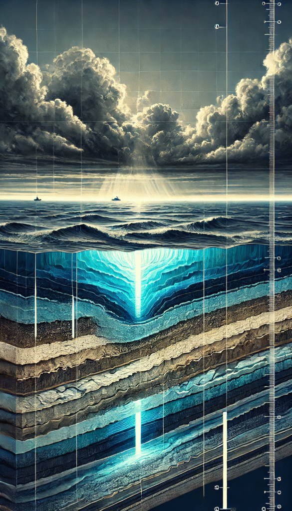
In a groundbreaking study, scientists have mapped what may be the largest undersea freshwater aquifer yet discovered, stretching along the northeastern seaboard of the United States, from Massachusetts to New Jersey, and extending up to 75 miles offshore beneath the Atlantic Ocean. Hidden within the sediments of the continental shelf, this immense freshwater reserve—if found on land—would cover an estimated 15,000 square miles, roughly the size of Lake Michigan.
The discovery, detailed by Chloe Gustafson and colleagues in Scientific Reports, was made possible through the use of electromagnetic imaging, a method adapted from offshore oil exploration. By measuring the conductance of sediments beneath the ocean floor—saltwater being a better conductor than fresh water—scientists were able to visualize vast zones of low-conductivity material, indicating the presence of fresh water in permeable sediments. Where older drill holes had once revealed isolated patches of freshwater, this new study confirmed that those pockets were not isolated at all—they were part of a massive, largely continuous undersea aquifer.
What makes this discovery especially significant is not just its size, but what it suggests: that similar offshore freshwater reserves may exist in many parts of the world. In regions facing growing water scarcity, such as parts of Africa, the Middle East, and Australia, offshore aquifers may one day serve as emergency freshwater sources—assuming we understand them well enough not to ruin them before they can be responsibly used.
The Origin Story: Fossil Water or Fresh Supply?
The pressing question in the scientific community now is whether this aquifer is “fossil water”—a remnant of glacial melt from the last Ice Age—or whether it is actively being replenished by modern terrestrial runoff. The answer holds profound implications. If the aquifer is being actively recharged, it could represent a sustainable water source. If it is fossil water, its exploitation could lead to irreversible depletion and environmental damage.
Evidence suggests both mechanisms may be at play. During the last glacial maximum, sea levels were approximately 100 meters lower than today, and large portions of the continental shelf were dry land. River deltas likely deposited freshwater into the sediment, and when sea levels rose, this water became trapped under impermeable layers. But researchers also suggest that modern runoff still feeds the aquifer. As water from rainfall and rivers percolates through terrestrial soils, it can be gradually pushed seaward through sediment layers by tidal pressures, much like squeezing water through a sponge.
Determining which process dominates requires sophisticated methods. Isotope dating techniques, including krypton-81 and carbon-14, allow scientists to estimate the age of groundwater. If the water contains tritium—an isotope introduced into the environment by 20th-century nuclear testing—it’s modern. Absence of tritium, or the presence of krypton-81, suggests water has been underground for tens or even hundreds of thousands of years. Ongoing drilling efforts as part of international scientific expeditions aim to answer this question definitively.
Don’t Get Too Excited: Risks of Extraction
The sheer size and potential utility of this aquifer might tempt policymakers to view it as a solution to water scarcity problems. But many scientists are urging caution. If this reserve turns out to be fossil water with little or no recharge, extracting it would amount to unsustainable mining of a non-renewable resource. Once gone, it wouldn’t come back for tens of thousands of years—if at all.
Even more troubling are the potential geological consequences of disturbing such a large undersea system. On land, aquifer over-extraction has led to serious problems, such as land subsidence in California’s Central Valley and Mexico City. As water is removed, the porous spaces in underground sediments collapse, causing the land above to sink. Similar effects could occur offshore, leading to submarine sediment collapse, or worse, disturbance of fault zones.
Undersea fault systems, already stressed by tectonic activity, may be influenced by changes in pore pressure within nearby aquifers. Lowering this pressure through extraction can reduce the friction that keeps faults stable, potentially triggering undersea earthquakes or landslides. In the worst case, this could result in localized tsunamis or major seafloor instability. Such outcomes remain speculative, but not implausible—earthquake activity in Oklahoma has already been linked to fluid injection and extraction in the subsurface.
A Slow-Motion Crisis on Land
It’s important to note that land-based aquifers have already demonstrated what happens when groundwater is treated like an infinite resource. The Ogallala Aquifer, which stretches under eight U.S. states, is being depleted at alarming rates, with some areas experiencing water table drops of over 150 feet. The Central Valley in California has sunk as much as 30 feet in places due to over-pumping. In many parts of the world, groundwater is used faster than it recharges, creating a slow-motion environmental and agricultural collapse.
Globally, major land aquifers such as the Indo-Gangetic Basin (South Asia), the Arabian Aquifer System (Middle East), the North China Plain Aquifer, and the Nubian Sandstone Aquifer (North Africa) all show signs of unsustainable use. Many of these are located in densely populated or arid regions, where groundwater is the only reliable water source. As demand continues to grow, the temptation to exploit undersea reserves will only increase.
The Case for Caution and Curiosity
Understanding the undersea aquifer off the U.S. Northeast is not just a scientific puzzle—it’s a potential blueprint for managing future water crises. If similar aquifers exist elsewhere, they could become part of the global water security strategy. But only if we understand:
- How much water they hold,
- Whether they are renewable,
- How vulnerable they are to contamination,
- And what geological risks extraction might pose.
So far, the Northeast aquifer remains untouched by industry—but that won’t last forever. Scientific exploration now, including the use of electromagnetic mapping, isotope dating, and core sampling, is essential not just to answer academic questions, but to inform policy before decisions are made.
In the meantime, the offshore aquifer remains a silent titan—a relic of ancient ice and rain, hiding in the sediments, whispering both promise and peril. It is the water beneath the ocean. But whether it becomes salvation or tragedy depends entirely on what we choose to do next.
