How GPS Works
Global Positioning System (GPS) is a satellite-based navigation system that allows users to determine their exact location (latitude, longitude, and altitude) anywhere on Earth. The system is composed of three segments: the space segment, the control segment, and the user segment.
1. Space Segment
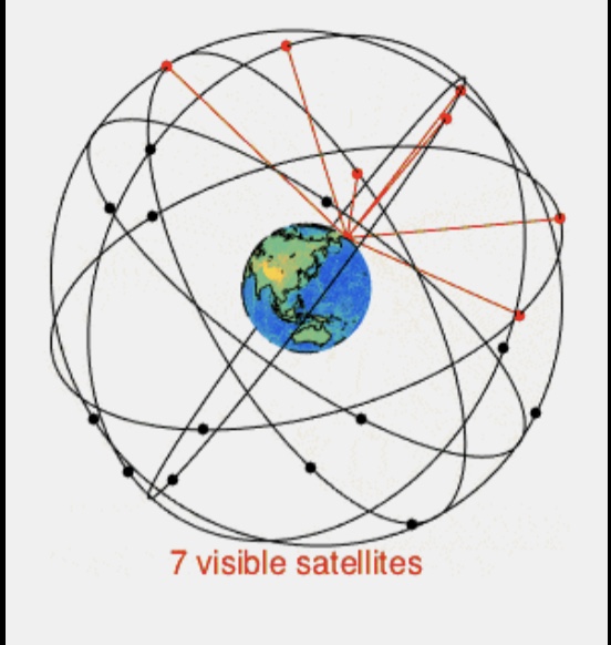
- Satellites: The space segment consists of a constellation of at least 24 satellites orbiting the Earth at an altitude of about 20,200 kilometers (12,550 miles). These satellites are arranged in six orbital planes, with each plane containing four satellites. This arrangement ensures that at least four satellites are visible from any point on the Earth’s surface at any given time.
- Orbital Period: Each satellite completes an orbit approximately every 12 hours.
2. Control Segment
- Ground Stations: The control segment includes a network of ground stations located around the world. These stations track the satellites, monitor their transmissions, and send commands to the satellites. The main components of the control segment are the Master Control Station (MCS), the Monitor Stations, and the Ground Antennas.
- Functions: The MCS processes the data received from the monitor stations and calculates the satellites’ precise orbits and clock corrections. This information is then uploaded to the satellites to ensure their signals are accurate.
3. User Segment
- GPS Receivers: The user segment consists of GPS receivers, which can be found in various devices such as smartphones, cars, airplanes, and dedicated GPS units.
- Functions: GPS receivers calculate their position by processing signals from multiple GPS satellites.
How GPS Determines Position
1. Signal Transmission
- Satellite Signals: Each GPS satellite continuously transmits a signal that includes:
- The satellite’s position (ephemeris data).
- The exact time the signal was transmitted (clock data).
- General system health and status information (almanac data).
2. Signal Reception
- Receivers: A GPS receiver needs to receive signals from at least four satellites to accurately determine its three-dimensional position (latitude, longitude, and altitude). The receiver measures the time it takes for the signals to travel from the satellites to the receiver.
- Time of Flight: By knowing the time of transmission and the time of reception, the receiver can calculate the distance to each satellite. This distance is known as the pseudorange.
3. Trilateration
- Calculating Position: The receiver uses the distances to at least four satellites to perform trilateration. Trilateration involves solving a series of equations to determine the receiver’s exact position.
- Clock Error Correction: Since the receiver’s clock is not as precise as the atomic clocks on the satellites, the receiver also calculates and corrects its clock error during this process.
Signal Components and Data
- C/A Code: The coarse/acquisition code is a pseudorandom noise (PRN) sequence that allows the receiver to determine the signal’s travel time.
- P(Y) Code: A more precise code used by military receivers.
- L1 and L2 Frequencies: GPS signals are transmitted on multiple frequencies. The L1 frequency (1575.42 MHz) carries the C/A code, and the L2 frequency (1227.60 MHz) carries the P(Y) code. Dual-frequency receivers can use both frequencies to correct for ionospheric delay, improving accuracy.
Sources of Error and Accuracy
- Ionospheric and Tropospheric Delays: Signal propagation through the Earth’s atmosphere can cause delays.
- Multipath Effects: Signals reflecting off buildings or other surfaces can cause errors.
- Satellite Clock and Orbital Errors: Inaccuracies in the satellite’s clock or orbit data can affect the signal.
- Receiver Noise: The inherent noise in the receiver’s electronics can introduce errors.
Enhancements
- Differential GPS (DGPS): Uses ground-based reference stations to broadcast corrections to GPS signals, improving accuracy to within a few centimeters.
- Satellite-Based Augmentation Systems (SBAS): Such as WAAS (Wide Area Augmentation System), which provides additional correction signals to improve accuracy.
Applications
GPS is used in various fields, including navigation (land, air, sea), mapping and surveying, timing and synchronization for telecommunications, and tracking and logistics for managing vehicle fleets.
Conclusion
GPS is a complex but highly reliable system that provides critical positioning and timing information to users worldwide. Its combination of satellite technology, ground control, and user equipment enables a wide range of applications that have become integral to modern life.
There are several global and regional satellite-based navigation systems (GNSS) used worldwide. Here are the main types:
Global Systems
- GPS (Global Positioning System)
- Country: United States
- Details: The first and most widely used GNSS, with a constellation of at least 24 satellites.
- GLONASS (Global Navigation Satellite System)
- Country: Russia
- Details: Russia’s GNSS, fully operational with a constellation of 24 satellites.
- Galileo
- Country: European Union
- Details: Europe’s GNSS, which aims to provide highly accurate global positioning service. It plans to have a full constellation of 30 satellites.
- BeiDou (BDS)
- Country: China
- Details: China’s GNSS, which has a constellation of 35 satellites and offers services globally.
Regional Systems
- QZSS (Quasi-Zenith Satellite System)
- Country: Japan
- Details: A regional GNSS designed to enhance GPS coverage in the Asia-Oceania region, particularly Japan, with a planned constellation of 7 satellites.
- NavIC (Navigation with Indian Constellation)
- Country: India
- Details: Also known as IRNSS (Indian Regional Navigation Satellite System), it provides accurate position information to users in India and the surrounding region with a constellation of 7 satellites.
- KPS (Korean Positioning System)
- Country: South Korea
- Details: South Korea’s planned regional navigation system aimed at enhancing GPS accuracy in the Korean Peninsula.
These systems vary in their scope and functionality, with global systems providing worldwide coverage and regional systems focusing on specific areas to enhance the performance of global systems or to provide independent navigation capabilities.
GPS systems are under increasing threat from various forms of interference, primarily due to geopolitical tensions and advancements in electronic warfare techniques.
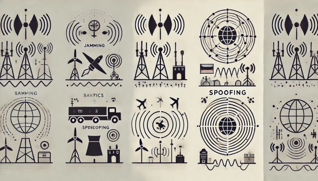
Types of Attacks on GPS
- Jamming: This involves transmitting signals on the same frequencies as GPS, overpowering the legitimate signals and making them unusable. This has been notably prevalent in regions like the Baltics and Ukraine, where Russian forces have been reported to deploy jammers to disrupt GPS signals for both military and civilian navigation systems.
- Spoofing: This is a more sophisticated attack where fake GPS signals are sent to deceive receivers about their actual location. Countries like Russia, Iran, and China have increasingly used these techniques for strategic purposes, such as misleading military assets and disrupting civilian infrastructure.
Geopolitical Motivations
Russia has been particularly aggressive in using GPS interference as a tool of hybrid warfare. This includes jamming activities in Ukraine and the Baltic states as part of broader efforts to challenge Western influence and NATO activities near its borders. Such interference not only affects military operations but also poses significant risks to civilian aviation and maritime navigation, potentially leading to accidents and economic disruptions.
Broader Implications
These attacks highlight vulnerabilities in the GPS system, which is crucial for various applications beyond navigation, including telecommunications, banking, and emergency services. The fragmentation of global navigation satellite systems (GNSS), with countries developing their own systems (e.g., China’s BeiDou, Europe’s Galileo, and Russia’s GLONASS), adds to the complexity and security challenges. This diversification can reduce reliance on any single system but also increases the risk of interference and cyberattacks.
Mitigation Efforts
To counter these threats, there are ongoing efforts to enhance the resilience of GPS and develop alternative systems. This includes upgrading to more advanced satellites with better anti-jamming capabilities and exploring new technologies like low-Earth orbit (LEO) satellite constellations and ground-based positioning systems. The U.S., for instance, is working on the GPS 3F satellite upgrade and the next-gen navigation system NTS-3, though these developments are still years away from full deployment.
In conclusion, the growing prevalence of GPS jamming and spoofing underscores the need for robust international cooperation and rapid technological advancements to safeguard critical infrastructure and maintain global navigation reliability oai_citation:1,As Baltics see spike in GPS jamming, NATO must respond – Breaking Defense oai_citation:2,Global navigation jamming will only get worse. The U.S. needs to move fast – SpaceNews oai_citation:3,Russia is jamming GPS satellite signals in Ukraine, US Space Force says | Space.
Gemini:
While GPS is a critical technology for numerous applications, it is also vulnerable to several types of attacks and disruptions.
Why GPS is Under Attack:
- Strategic Importance: GPS is essential for military operations, navigation, timing, and many critical infrastructure systems. Disrupting GPS can have significant strategic implications.
- Vulnerabilities: GPS signals are relatively weak and can be easily jammed, spoofed, or disrupted by various means. This makes it an attractive target for malicious actors.
- Financial Gain: Criminals may attempt to exploit GPS vulnerabilities for financial gain, such as by spoofing signals to manipulate location-based services or disrupting transportation systems for ransom.
How GPS is Under Attack:
- Jamming: Jamming involves transmitting a stronger signal on the same frequency as GPS signals, effectively drowning them out and preventing receivers from acquiring a lock. This can be done intentionally or unintentionally through interference from other devices.
- Spoofing: Spoofing involves transmitting counterfeit GPS signals that mimic legitimate ones, but with incorrect location and time information. This can trick receivers into calculating incorrect positions, leading to dangerous situations for navigation systems.
- Cyberattacks: GPS infrastructure, including satellites and ground stations, can be vulnerable to cyberattacks. Hackers could attempt to disrupt or manipulate GPS signals through cyber intrusions.
- Physical Attacks: In extreme cases, physical attacks on GPS satellites or ground stations could disrupt the system, but this is less likely due to the high cost and difficulty of such attacks.
Examples of GPS Attacks:
- Shipping Industry: Ships have reported incidents of GPS spoofing, where their navigation systems showed incorrect locations, potentially leading to collisions or grounding.
- Drones: Drones are particularly vulnerable to GPS jamming and spoofing, which can cause them to lose control or be hijacked.
- Financial Markets: GPS provides precise timing for financial transactions. Disruptions to GPS could cause chaos in financial markets.
Mitigation Efforts:
Efforts are underway to mitigate the risks of GPS attacks, including:
- Redundancy: Developing backup navigation systems that can operate independently of GPS in case of disruption.
- Signal Authentication: Implementing methods to authenticate GPS signals and detect spoofing attempts.
- Anti-Jamming Technologies: Developing technologies to counter GPS jamming and spoofing.
- Cybersecurity Measures: Strengthening the cybersecurity of GPS infrastructure to protect against cyberattacks.
Conclusion:
The threat to GPS is real and ongoing. While GPS remains a valuable and widely used technology, it’s important to be aware of its vulnerabilities and to take steps to mitigate the risks of attacks and disruptions.