ChatGPT:
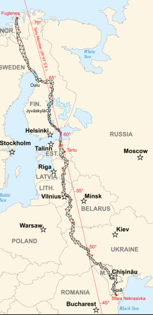
The Struve Geodetic Arc is a chain of survey triangulations established in the 19th century to measure the shape and size of the Earth. It spans over 2,820 kilometers and crosses ten countries: Norway, Sweden, Finland, Russia, Estonia, Latvia, Lithuania, Belarus, Ukraine, and Moldova. This arc is a UNESCO World Heritage Site, recognized for its scientific and historical significance.
Origin and Purpose
The Struve Geodetic Arc was initiated by Friedrich Georg Wilhelm Struve, a German-born Russian astronomer and geodesist. The project began in 1816 and continued until 1855. Its main goal was to calculate the exact shape of the Earth (a slightly flattened sphere or ellipsoid) by determining the length of a meridian arc, which helps to understand the Earth’s dimensions more accurately.
At the time, determining the Earth’s size was critical for advancing cartography, navigation, and understanding geophysics.
How It Was Created
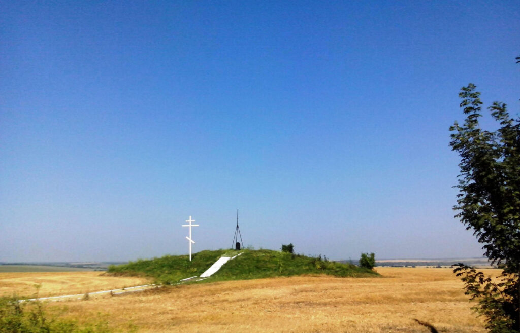
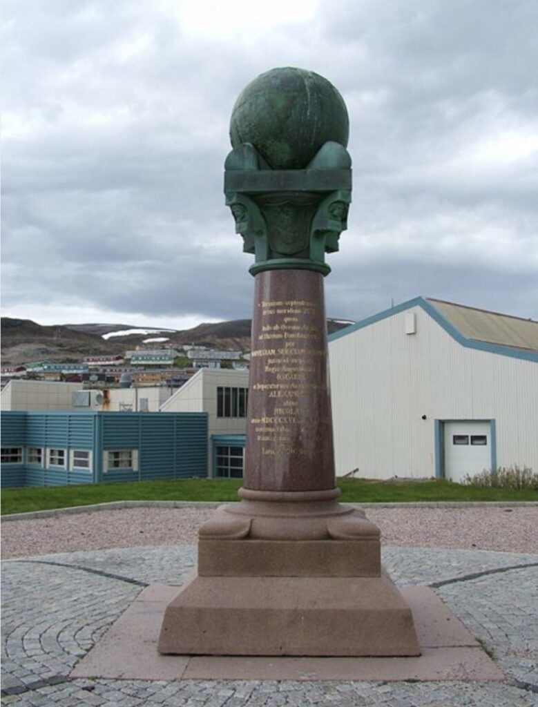
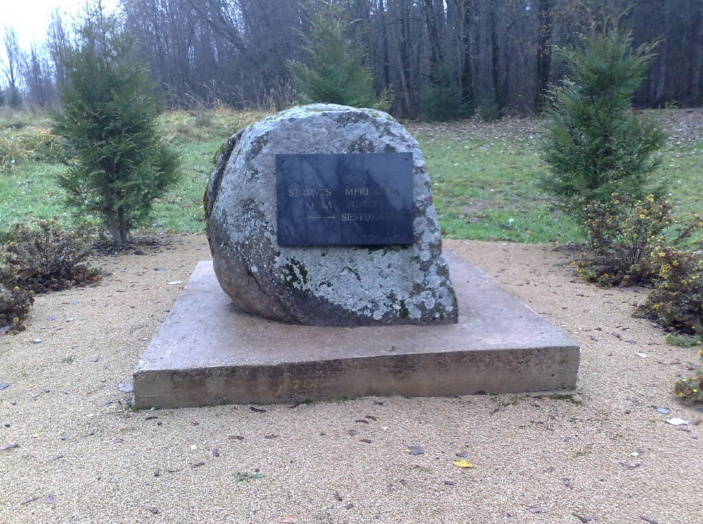
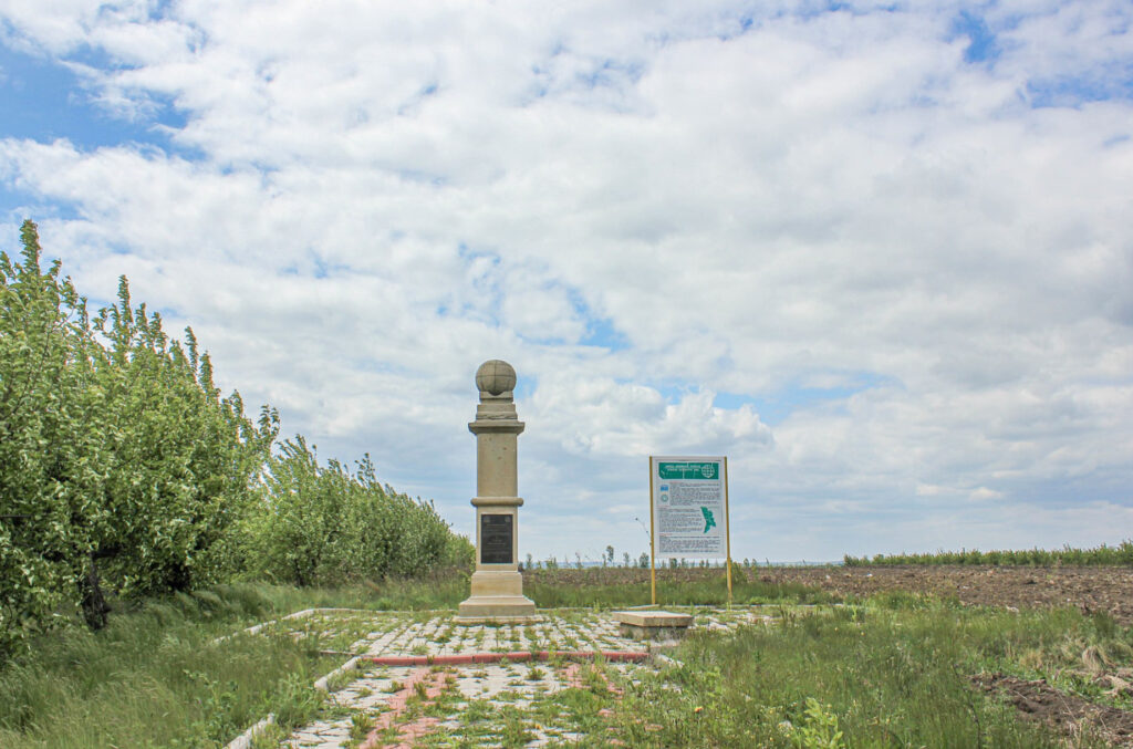
The arc consists of 258 main triangulation points, many marked by permanent structures such as cairns, obelisks, or holes drilled in rocks. These points were linked through a triangulation method, where distances were measured using trigonometric calculations rather than direct measurement.
Struve’s work was groundbreaking because:
• It was one of the first large-scale, precise geodetic measurements over such a vast territory.
• It demonstrated international cooperation in science, involving multiple nations.
Significance
The Struve Geodetic Arc contributed significantly to geodesy, astronomy, and mapping:
• It validated Sir Isaac Newton’s hypothesis that the Earth is an oblate spheroid (flattened at the poles and bulging at the equator).
• It laid the groundwork for modern surveying and geospatial science.
Recognition
In 2005, the Struve Geodetic Arc was designated as a UNESCO World Heritage Site for its outstanding universal value. While the original arc spanned 258 stations, only 34 points were included in the UNESCO listing. These points were chosen for their well-preserved condition and representation of the arc’s original scope.
Legacy
The Struve Geodetic Arc remains a testament to the power of scientific collaboration and innovation in the 19th century. It also highlights the enduring relevance of geodetic science in understanding the planet’s physical characteristics and mapping the globe.
Friedrich Georg Wilhelm Struve (1793–1864) was a German-born Russian astronomer and geodesist whose pioneering work bridged the fields of astronomy, geodesy, and mathematics. His contributions laid the groundwork for modern scientific understanding of Earth’s shape and celestial mechanics.
Early Life and Education
• Born in Altona, in present-day Germany, Struve grew up during a time of scientific awakening in Europe.
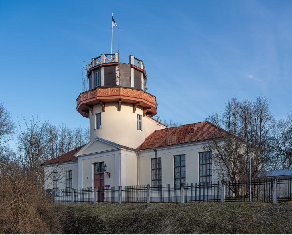
• In 1808, he moved to the Russian Empire and enrolled at the University of Dorpat (now Tartu, Estonia), where he studied philology before transitioning to astronomy.
Contributions to Astronomy
1. Observations of Double Stars:
Struve was renowned for his meticulous studies of double stars. He cataloged thousands of them, providing insights into binary star systems and their gravitational interactions. His work helped confirm Newtonian mechanics on a cosmic scale.
2. Development of Tartu Observatory:
As director of the Tartu Observatory, Struve transformed it into a leading center for astronomical research, equipped with one of the most advanced refracting telescopes of the era.
3. The “Struve Constant”:
Struve determined precise values for the constant of refraction in Earth’s atmosphere, advancing the accuracy of astronomical measurements.
Contributions to Geodesy
1. The Struve Geodetic Arc:
Struve’s most famous geodetic work involved establishing the Struve Geodetic Arc (1816–1855), a 2,820-kilometer-long chain of triangulations to measure Earth’s meridian arc. This work confirmed the Earth’s shape as an oblate spheroid (flattened at the poles).
2. Scientific Collaboration:
The arc was one of the first large-scale international scientific projects, involving surveyors from ten countries. Struve’s leadership ensured its success, marking a milestone in global scientific cooperation.
Legacy
• Struve’s work earned him numerous accolades, including recognition from the Royal Astronomical Society and the Russian Academy of Sciences.
• He founded a dynasty of astronomers, with several of his descendants making notable contributions to the field.
• His name lives on in the Struve Geodetic Arc, a UNESCO World Heritage Site, and in the Struve crater on the Moon.
Struve’s life exemplifies the fusion of rigorous science and international collaboration, demonstrating how precision and vision can advance humanity’s understanding of the cosmos and the planet.
The Struve Geodetic Arc physically and symbolically connects Europe and Asia as a pioneering scientific endeavor that transcended borders during the 19th century. Here’s how:
Physical Connection
1. Geographical Extent Across Two Continents:
The arc spans over 2,820 kilometers, stretching from Hammerfest, Norway in the north to Izmail, Ukraine (then part of Moldova) in the south. This path crosses ten countries, including Russia, which geographically bridges Europe and Asia.
2. Markers as a Network Across Nations:
The arc consists of 258 triangulation points, some of which lie near Europe-Asia border regions, emphasizing its role as a unifying network. These markers are physical remnants of a collaborative scientific project that linked distant and diverse regions.
3. Scientific Unity of the Continents:
By measuring a meridian arc through both European and Asian territories, the project unified the understanding of Earth’s dimensions, contributing to geodesy on a global scale.
Symbolic Connection
1. Collaboration Across Borders:
The Struve Geodetic Arc symbolized international cooperation at a time when the participating regions were under different political regimes, including the Russian Empire and various European states. It demonstrated that science could bridge political and cultural divides.
2. Shared Scientific Goals:
The arc was a joint effort to measure the Earth, requiring shared methodologies, tools, and expertise across nations and continents. It highlighted the universal nature of scientific inquiry.
3. Cultural and Historical Integration:
The arc’s markers exist in regions with diverse cultures, languages, and histories, reflecting the interconnectedness of Europe and Asia. Its inclusion as a UNESCO World Heritage Site acknowledges this cultural mosaic.
4. Global Implications of Local Measurements:
While the arc measured a specific meridian, its findings had implications for global geodesy, navigation, and mapping. This reinforces its symbolic role as a bridge between continents in advancing human understanding of the planet.
In both its geographical scope and its spirit of collaboration, the Struve Geodetic Arc serves as a literal and metaphorical connection between Europe and Asia, embodying the idea that science unites humanity across borders.
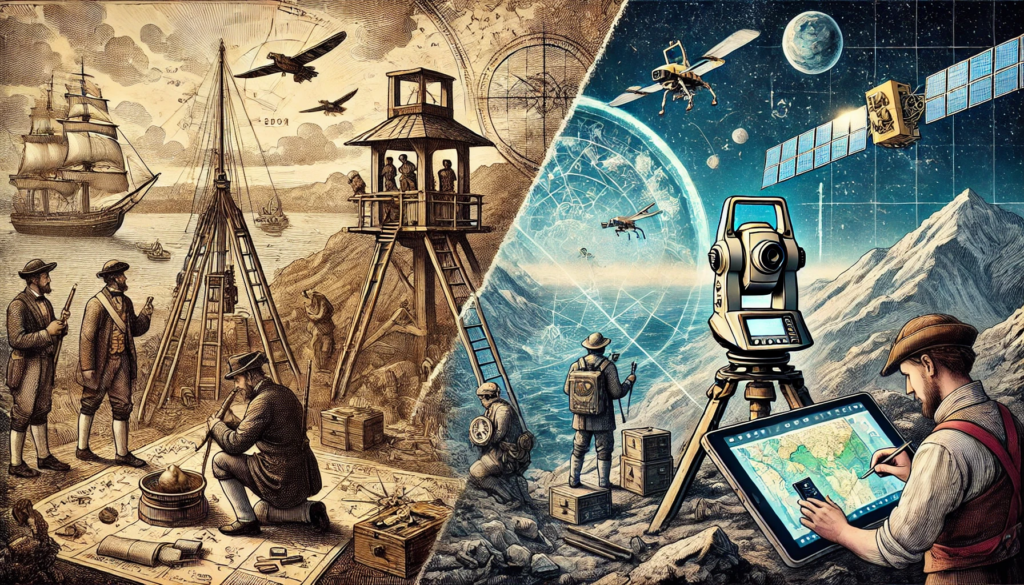
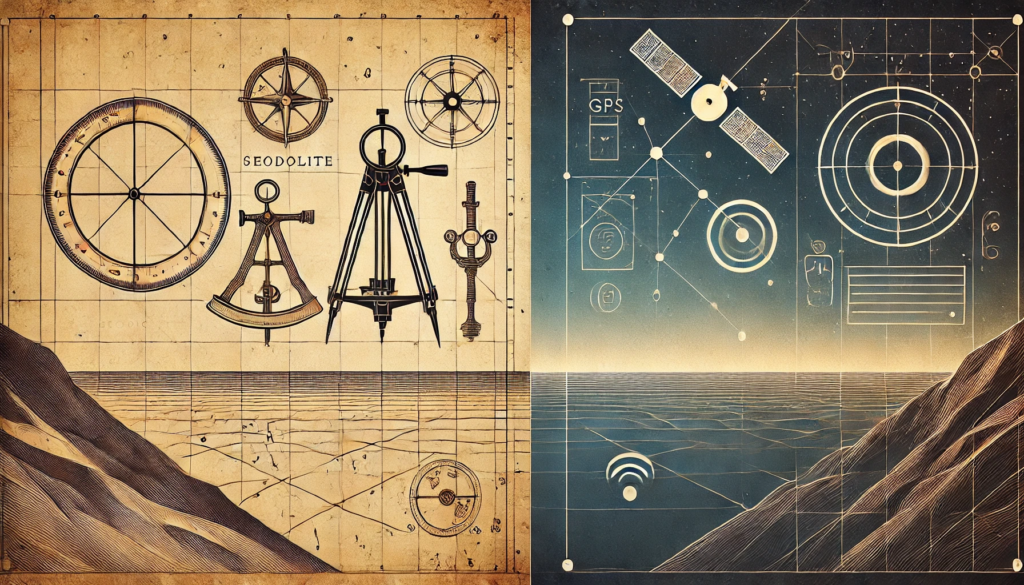
The Struve Geodetic Arc’s 19th-century methodology contrasts sharply with modern geospatial and satellite technologies in terms of tools, precision, and scale. However, its foundational principles remain relevant today.
19th-Century Methodology: The Struve Geodetic Arc
1. Triangulation Technique:
• The arc relied on triangulation, a method that involves measuring angles in a series of connected triangles and calculating distances based on a precisely measured baseline.
• The work required accurate angle measurements using theodolites and laborious calculations by hand.
2. Physical Baselines:
• Surveyors established a few very precise baselines, sometimes several kilometers long, which served as the foundation for the entire triangulation network.
3. Manual Labor and Logistics:
• Surveying involved on-site work, often in remote areas, requiring careful placement of markers (cairns, drilled holes, or obelisks).
• The process took decades (1816–1855) due to the slow, manual nature of the work.
4. Precision and Limitations:
• The measurements were remarkably accurate for the time, with errors minimized through meticulous observation.
• However, the technique was limited by terrain, weather, and the technology available, making it impractical for global or dynamic measurements.
Modern Geospatial and Satellite Technologies
1. Satellite-Based Systems:
• Technologies like Global Navigation Satellite Systems (GNSS) (e.g., GPS, GLONASS, Galileo) use satellites to determine positions on Earth with centimeter-level accuracy.
• Satellites continuously orbit the Earth, providing real-time, dynamic measurements across the globe.
2. Geodetic Networks:
• Modern networks rely on satellite laser ranging (SLR), Very Long Baseline Interferometry (VLBI), and Doppler orbitography, offering extreme precision over vast distances without the need for ground-based triangulation.
3. Digital Tools and Automation:
• Sophisticated software automates calculations, allowing for rapid data processing and visualization.
• Geographic Information Systems (GIS) integrate this data for diverse applications like mapping, urban planning, and environmental monitoring.
4. Global and Dynamic Scope:
• Modern technologies account for Earth’s dynamic changes, including tectonic movements and gravitational variations, providing a far more comprehensive understanding.
5. Precision and Scale:
• Errors are minimized to millimeters, a level of precision unimaginable in the 19th century.
• Measurements are not limited to local or regional scales but extend globally, aiding in navigation, agriculture, and disaster management.
Comparison
Aspect Struve Geodetic Arc Modern Technologies
Method Triangulation with physical markers Satellite-based positioning
Tools Theodolites, chains, baselines GNSS, GIS, remote sensing equipment
Timeframe Decades to complete Real-time, dynamic measurements
Precision High for the era but regionally constrained Sub-millimeter, global accuracy
Scope Limited to one meridian Covers the entire planet
Challenges Manual labor, weather, and terrain Satellite maintenance and signal loss
Legacy and Relevance
The Struve Geodetic Arc laid the groundwork for modern geodesy by demonstrating the value of precise, coordinated measurement systems. Its principles of triangulation underpin many contemporary geospatial methods, while its markers serve as a reminder of humanity’s enduring quest to understand the planet. Today, modern technologies achieve far greater accuracy and scale, but they build directly on the foundation that projects like the Struve Geodetic Arc established.