ChatGPT:
The Longest Lightning Flash in History: The Science and Wonder of a 515-Mile Megaflash
On October 22, 2017, a remarkable event unfolded in the skies above the U.S. Great Plains. A single flash of lightning — stretching from eastern Texas to near Kansas City — was later confirmed by the World Meteorological Organization (WMO) as the longest lightning flash ever recorded. Covering a staggering distance of 515 miles, this “megaflash” rewrote the record books, dwarfing the average lightning bolt, which typically spans less than 10 miles. Although the event lasted only a few seconds, it revealed astonishing truths about the atmosphere’s power and complexity, as well as the fundamental physics that make lightning one of nature’s most awe-inspiring spectacles.
Understanding Lightning: More Than a Flash
Lightning is often seen as a sudden bolt that strikes the ground during a thunderstorm, accompanied by thunder and perhaps a flicker of lights. But lightning can be much more complex. It is the dramatic consequence of charge separation within storm clouds — a result of turbulent motions, ice collisions, and rising and sinking air that create electrical imbalance. When that imbalance becomes too great, the atmosphere’s natural insulation breaks down, and electricity rushes through the air in the form of a lightning discharge.
In the case of the 2017 megaflash, this discharge didn’t travel vertically toward the ground. Instead, it moved horizontally, covering more than 500 miles through a network of thunderstorm clouds. Lightning of this kind — termed “intra-cloud” or “cloud-to-cloud” lightning — is more common than most people realize. However, megaflashes are exceptionally rare because they require the perfect atmospheric conditions: an enormous and connected thunderstorm system that stretches across multiple states, along with a stable layer in the atmosphere that allows the lightning to propagate horizontally for extended distances.
How Lightning Forms: The Role of Charged Particles
To understand how lightning — especially something as large as a megaflash — can form, we must look inside the storm clouds. Thunderstorm clouds, or cumulonimbus clouds, are highly dynamic systems. Inside them, air is constantly moving upward and downward in powerful currents. These motions cause tiny particles — including ice crystals, supercooled water droplets, and graupel (soft hail) — to collide with each other.
During these collisions, electrical charges are transferred. Generally, lighter ice crystals become positively charged and are carried upward by the rising air. Heavier graupel particles tend to become negatively charged and fall to lower parts of the cloud. This vertical movement of differently charged particles creates a separation of charge within the cloud: positive charges accumulate at the top and negative charges gather near the bottom.
This separation sets the stage for lightning. The atmosphere can normally resist electrical breakdown, but as the charge imbalance intensifies, the electric field becomes strong enough to overcome this resistance. When this happens, a lightning discharge occurs to balance the electric field. In a typical storm, this discharge may travel a few miles — from one part of the cloud to another, or from the cloud to the ground. But under unique conditions, the discharge can span hundreds of miles, as it did in the 2017 megaflash.
The Speed of Light and the Power of Sound
One of the most astonishing aspects of the 2017 megaflash is how such a vast event lasted only a few seconds. To the human eye, the flash might appear like a momentary flicker, but behind the scenes, complex processes are unfolding at tremendous speed.
Electricity in a lightning bolt moves incredibly fast — a large portion of it travels at a significant fraction of the speed of light (about 200,000 km/s in air). This means that even if a lightning bolt stretches over hundreds of miles, the electrical discharge can complete its journey almost instantaneously. The megaflash likely ignited in segments, with one part triggering the next, in a cascading sequence that unfolded in just a few seconds. Like a row of dominoes falling in quick succession, the flash swept across the storm system with astonishing speed and precision.
While the light from the flash reaches observers almost instantly, the sound — thunder — travels much more slowly. Sound moves through air at about 343 meters per second (or 0.21 miles per second), meaning it would take over 40 minutes for the thunder from one end of the 515-mile flash to reach someone standing at the other end. However, in real-world conditions, the sound of thunder doesn’t carry that far. It’s absorbed and scattered by the atmosphere, meaning that you wouldn’t hear thunder rolling in for three-quarters of an hour. Still, in theory, that’s how long the sound waves would take to cover the full distance.
A Visualization of Power
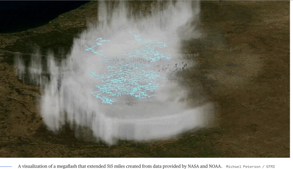
NASA and NOAA used satellite data to reconstruct the path of the 2017 megaflash. A visualization of the event shows a sprawling web of electrical tendrils stretching across the landscape, weaving through a cloud system that appears almost too vast to imagine. This was not a bolt that zigzagged from a cloud to a tree — it was a continent-spanning branch of light, crawling across the sky like an enormous neural impulse.
What makes the visualization so compelling is that it reveals the hidden structure of storms. Lightning is not simply a localized spark, but a manifestation of massive, distributed energy stored in the atmosphere. The megaflash acts as a kind of electrical short-circuit — not between earth and sky, but within the cloud canopy itself.
The Megaflash and the Future of Lightning Research
The confirmation of the 2017 megaflash as the longest lightning flash in recorded history is more than a curiosity. It represents a step forward in our understanding of extreme weather. Modern satellite systems, such as NASA’s GOES-R and Europe’s Meteosat Third Generation, allow scientists to observe storms with unprecedented detail. These instruments track lightning flashes from space, capturing events that ground-based observers might miss entirely.
Studying megaflashes helps meteorologists improve thunderstorm prediction models and deepen their understanding of how electrical energy is stored and released in the atmosphere. It also has practical implications: long-range lightning poses risks to aircraft, infrastructure, and even human health in ways not fully appreciated before.
Conclusion: A Flash, a Wonder, and a Window into Nature’s Power
The 515-mile megaflash of 2017 is a testament to the scale and speed of natural processes unfolding above us. Though lasting mere seconds, it spanned a distance greater than many road trips and held more power than we could safely harness. It formed not by chance, but through a finely balanced system of motion, moisture, and electrical charge deep within the storm clouds. In those few seconds, nature revealed a glimpse of its extraordinary machinery — a vast and silent current of energy illuminating the skies, too fast to chase, too powerful to ignore.
Lightning, especially on this scale, reminds us that the sky is alive with forces we are only beginning to understand. As our tools and observations improve, we will no doubt uncover even more spectacular phenomena — fleeting, brilliant flashes that tell the story of the Earth’s atmosphere in motion.

