ChatGPT:
Via Flaminia: Origin, Route, and History
The Via Flaminia was one of the most important ancient Roman roads, serving as a crucial artery connecting Rome to the northeastern regions of Italy and the Adriatic Sea. Constructed in 220 BC, it played a significant role in military campaigns, trade, and cultural exchange throughout the Roman Republic and the Roman Empire.
Origin
The road was commissioned by Gaius Flaminius, a Roman censor, statesman, and military leader known for his populist policies and infrastructural projects. His primary aim in building the Via Flaminia was to:
- Enhance Military Mobility: Provide a direct route for Roman legions to the northern frontiers.
- Promote Trade: Facilitate the movement of goods between Rome and the Adriatic ports.
- Consolidate Roman Influence: Strengthen control over recently conquered territories in the north.
Route
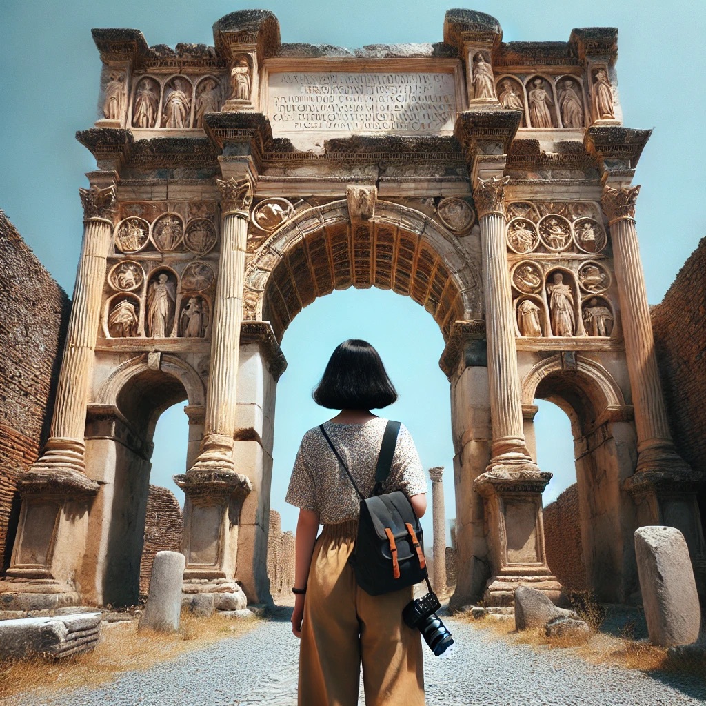
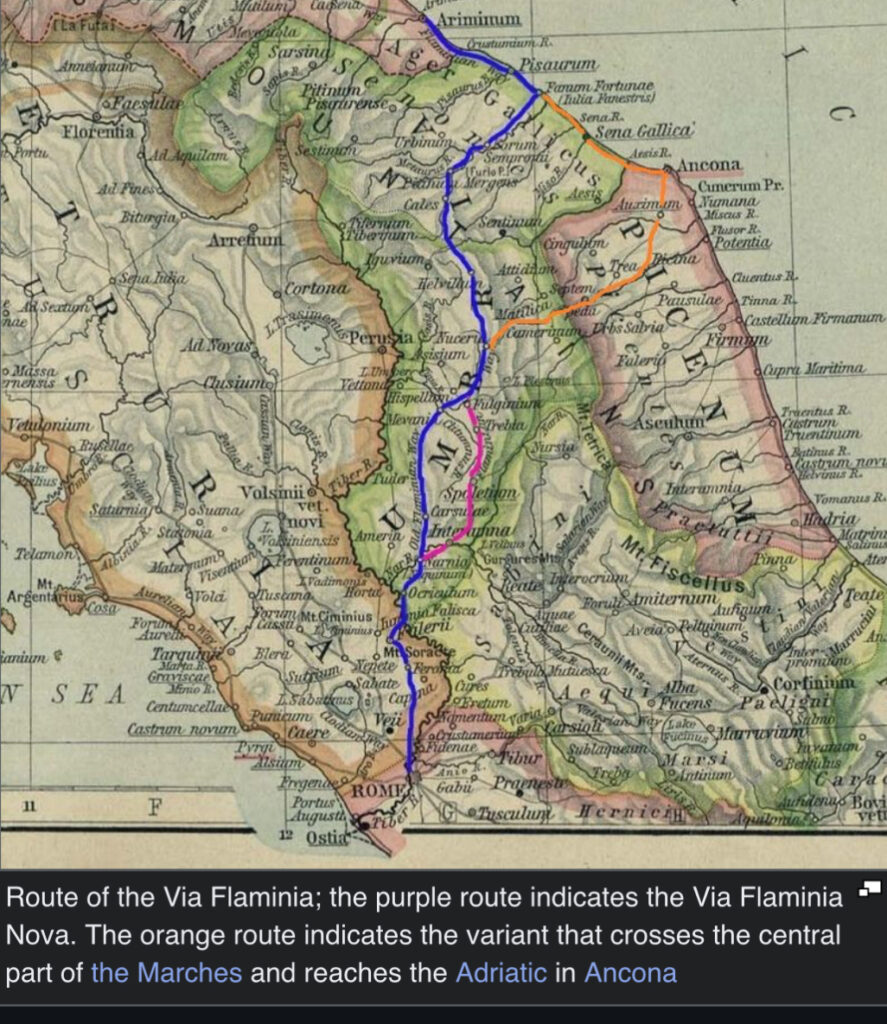
Starting at the Porta Flaminia (near today’s Piazza del Popolo in Rome), the Via Flaminia stretched approximately 220 kilometers (about 137 miles) to Ariminum (modern-day Rimini) on the Adriatic coast. The route can be outlined as follows:
- Rome to Saxa Rubra
- Crossed the River Tiber.
- Passed through Saxa Rubra, an area north of Rome.
- Saxa Rubra to Ocriculum (Otricoli)
- Followed the Tiber Valley.
- Ocriculum was an important way station.
- Ocriculum to Narnia (Narni)
- Entered Umbria.
- Crossed the Nera River via the impressive Ponte d’Augusto.
- Narnia to Interamna Nahars (Terni)
- Passed through fertile valleys.
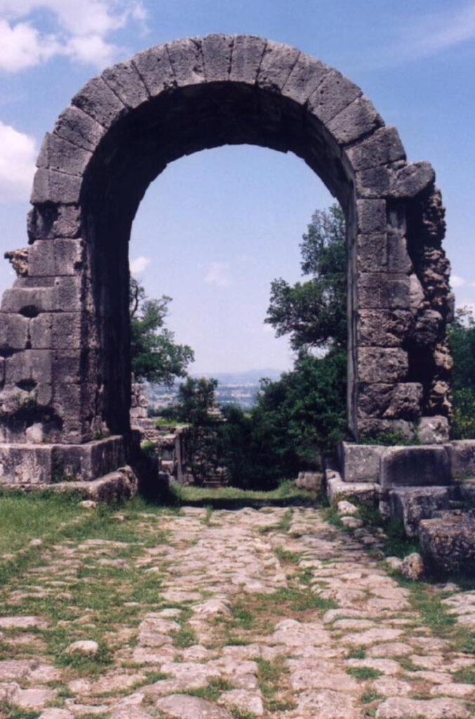
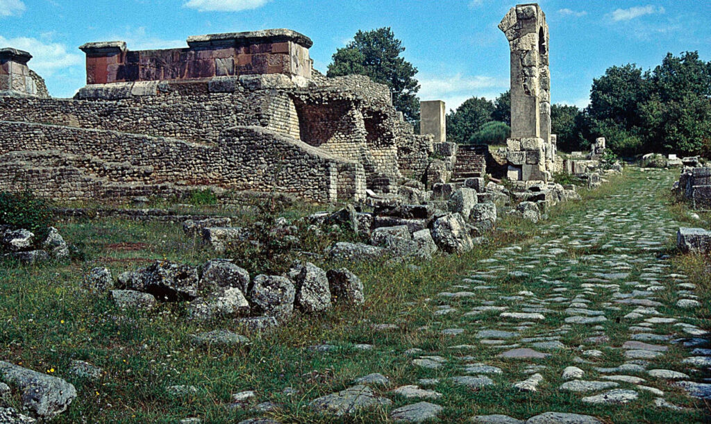
- Interamna to Carsulae
- Carsulae was a significant Roman town with well-preserved ruins today.
- Carsulae to Mevania (Bevagna)
- Traversed rolling hills and plains.
- Mevania to Forum Flaminii
- Founded by Flaminius himself.
- Served as a major crossroads.
- Forum Flaminii to Nuceria Camellaria (Nocera Umbra)
- Entered the Apennine Mountains.
- Nuceria to Helvillum (Sigillo)
- Crossed mountain passes.
- Helvillum to Cales (Cagli)
- Navigated through challenging terrains.
- Cales to Forum Sempronii (Fossombrone)
- Began descending towards the Adriatic.
- Forum Sempronii to Fanum Fortunae (Fano)
- Reached the coastal plains.
- Fanum Fortunae to Ariminum (Rimini)
- Followed the coastline northwest to the terminal point.
History
Republican Era (3rd–1st Century BC):
- Military Campaigns: Used extensively during wars against Gallic tribes and in the expansion into the Po Valley.
- Economic Development: Boosted trade and integration of northern territories.
Augustan Renovation (27 BC–14 AD):
- Infrastructure Improvements: Emperor Augustus ordered restorations, enhancing road surfaces, bridges, and milestones.
- Cultural Significance: Became a symbol of imperial power and unity.
Imperial Period (1st–3rd Century AD):
- Continued Use: Remained a vital route for commerce and military movements.
- Urban Development: Towns along the Via Flaminia prospered, with increased construction of villas, temples, and public buildings.
Late Antiquity (4th–6th Century AD):
- Strategic Importance: During the Gothic Wars, both Byzantine and Ostrogothic forces recognized its tactical value.
- Decline: Faced periods of neglect due to political instability but never entirely fell out of use.
Medieval Period to Modern Times:
- Medieval Adaptations: Portions of the road were maintained, serving pilgrims and merchants.
- Renaissance Interest: Renewed interest in Roman antiquities led to restorations.
- Modern Infrastructure: Today, the route is paralleled by modern highways like the Strada Statale 3 (SS3), and remnants of the original road can still be visited.
Architectural and Engineering Highlights
- Bridges: The Ponte d’Augusto in Narni showcases advanced Roman engineering with its massive stone arches.
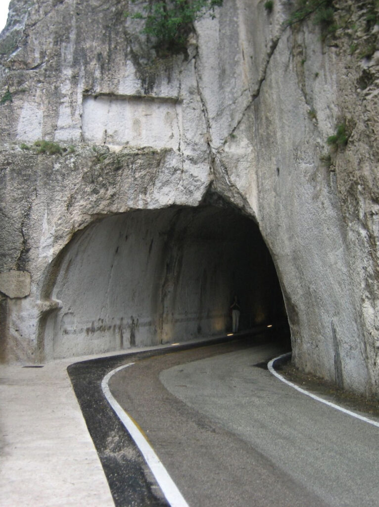
- Tunnels: The Galleria del Furlo, a tunnel carved through solid rock, allowed passage through the Furlo Pass.
- Milestones: Stone markers provided distances to Rome, many of which have been recovered and are displayed in museums.
- Road Design: Constructed with layers of stone and gravel for durability, featuring drainage systems.
Legacy
The Via Flaminia exemplifies the Roman commitment to connectivity and governance through infrastructure. Its construction:
- Unified Diverse Regions: Brought remote areas into the Roman fold culturally and economically.
- Influenced Future Road Building: Set standards for road construction in Europe.
- Cultural Heritage Site: Today, it offers valuable insights into Roman engineering and serves as an attraction for historians and tourists alike.
In Summary, the Via Flaminia was more than just a road; it was a catalyst for Roman expansion and cohesion. Its strategic design and enduring legacy reflect the ingenuity of Roman engineering and the importance placed on infrastructure in shaping history.
Construction Process of the Via Flaminia in Roman Times
The construction of the Via Flaminia was a remarkable feat of engineering that showcased the Roman Empire’s advanced techniques and organizational skills. Built in 220 BC under the direction of Gaius Flaminius, the road connected Rome to Ariminum (modern-day Rimini) on the Adriatic coast. The process involved meticulous planning, surveying, and the employment of a large workforce to overcome geographical challenges.
1. Planning and Surveying
- Route Selection: Roman engineers (agrimensores) carefully selected the most efficient path, balancing the need for a direct route with the natural contours of the landscape. They aimed to minimize gradients and avoid obstacles when possible.
- Use of Tools: Instruments like the groma (for creating straight lines and right angles) and the chorobates (a leveling instrument) were essential for accurate measurements.
- Securing Land: The Roman state negotiated with local populations to acquire land, sometimes reallocating property through eminent domain.
2. Workforce Organization
- Labor Sources:
- Roman Soldiers: Often utilized for their discipline and ability to work in organized units.
- Slaves and Local Laborers: Provided the bulk of the manual labor, including excavation and transport of materials.
- Division of Labor: Workers were organized into teams, each responsible for specific tasks such as excavation, stone cutting, or masonry.
3. Construction Phases
A. Clearing and Preparation
- Vegetation Removal: Trees, shrubs, and other vegetation were cleared to create a clear path.
- Leveling: High points were cut down, and low areas were filled to create a level foundation.
B. Foundation Laying
- Excavation of the Trench: A trench (fossa) was dug to accommodate the road’s foundational layers.
- Layered Foundation:
- Statumen: The bottom layer consisted of large, flat stones or rubble laid directly on the compacted earth for stability.
- Rudus: A middle layer of smaller stones mixed with lime mortar provided additional strength.
- Nucleus: A finer layer of crushed gravel or sand created a smooth base for the surface stones.
C. Surfacing
- Pavimentum: The road surface was made of tightly fitted paving stones, often polygonal in shape, providing a durable and smooth surface.
- Cambering: Roads were built with a slight arch (camber) to facilitate water runoff to the sides.
4. Engineering Techniques
A. Drainage Systems
- Side Ditches: Trenches on either side of the road collected runoff water.
- Culverts and Drains: Built to channel water under the road, preventing erosion of the foundation.
B. Bridges and Tunnels
- Bridges: Constructed using stone arches to cross rivers and valleys. The Ponte d’Augusto in Narni is a notable example.
- Tunnels: Carved through hillsides, such as the Galleria del Furlo, to maintain a straight route and reduce travel time.
C. Retaining Walls and Embankments
- Retaining Walls: Built to support the road in areas with steep slopes.
- Embankments: Raised sections constructed to keep the road level over uneven terrain.
5. Materials Used
- Stone: Local stone quarries supplied materials for foundations and paving.
- Mortar: Lime mortar, sometimes mixed with volcanic ash (pozzolana), was used as a binding agent.
- Timber: Employed in temporary structures and scaffolding during construction.
6. Overcoming Geographical Challenges
- Mountains: Roads were designed to traverse mountains with minimal steepness, using switchbacks or carving directly through rock.
- Rivers and Streams: In addition to bridges, fords were used where water levels permitted safe crossing.
- Marshlands: Causeways and drainage were implemented to prevent waterlogging and maintain road integrity.
7. Standards and Specifications
- Width: The Via Flaminia typically ranged from 4 to 6 meters (13 to 20 feet) wide, accommodating two-way traffic.
- Milestones (Milliaria): Stone markers placed every Roman mile (approximately 1,480 meters) indicated distances and provided information about the construction and repairs.
- Rest Stations:
- Mutationes: Simple stations for changing horses.
- Mansiones: More elaborate inns providing accommodations for travelers.
8. Maintenance and Upgrades
- Regular Maintenance: Ensured by local authorities or the state to keep the road in good condition.
- Imperial Oversight: Emperors and officials often commissioned repairs and enhancements, adding inscriptions to commemorate their contributions.
9. Impact of Construction Techniques
- Durability: The layered construction method contributed to the road’s longevity, with some sections still visible today.
- Efficiency in Movement: Facilitated faster movement of troops, goods, and information across the empire.
- Economic Growth: Improved trade routes boosted local economies and integrated remote regions with the capital.
10. Legacy
The construction of the Via Flaminia exemplified Roman engineering excellence and had a lasting impact on infrastructure development in Europe. Its methods influenced road-building techniques for centuries, emphasizing the importance of solid foundations, effective drainage, and meticulous planning.
In Summary, the Via Flaminia was more than a road; it was a strategic asset built through advanced engineering, careful planning, and efficient use of resources. The construction process reflected the Roman Empire’s priorities in military strategy, economic expansion, and administrative control, leaving a legacy that endures in modern engineering principles.
Adjusted One-Week Travel Itinerary Along the Via Flaminia: From Rome to Rimini
I’ll incorporate more hiking along the Via Flaminia into Day Three and Day Four of your itinerary. This will allow you to experience the ancient Roman road up close, enjoy the Umbrian countryside’s natural beauty, and explore charming towns along the way.
Day 1: Rome to Narni
Morning: Rome Exploration
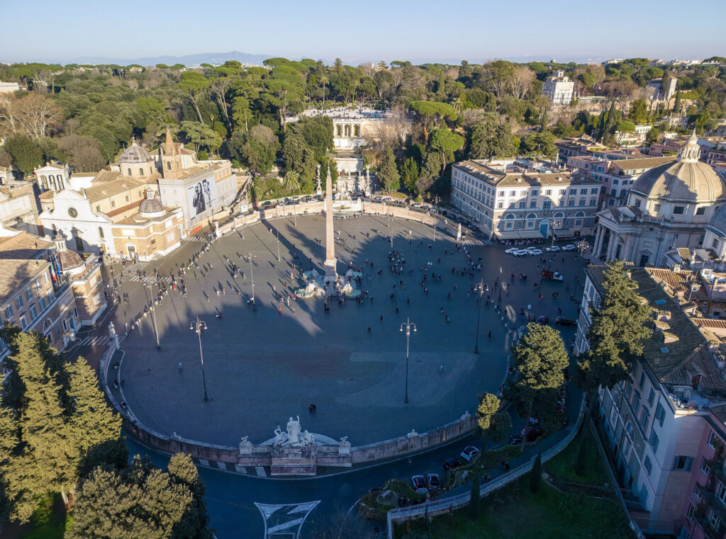
- Start at Piazza del Popolo: Visit the Porta del Popolo, the ancient Porta Flaminia, marking the start of Via Flaminia.
- Flaminio Obelisk: Admire the Egyptian obelisk brought to Rome by Emperor Augustus.
Afternoon: Journey to Narni
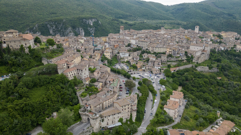
- Travel: Take a train or drive (~1 hour) to Narni, a medieval hilltop town.
- Explore Narni:
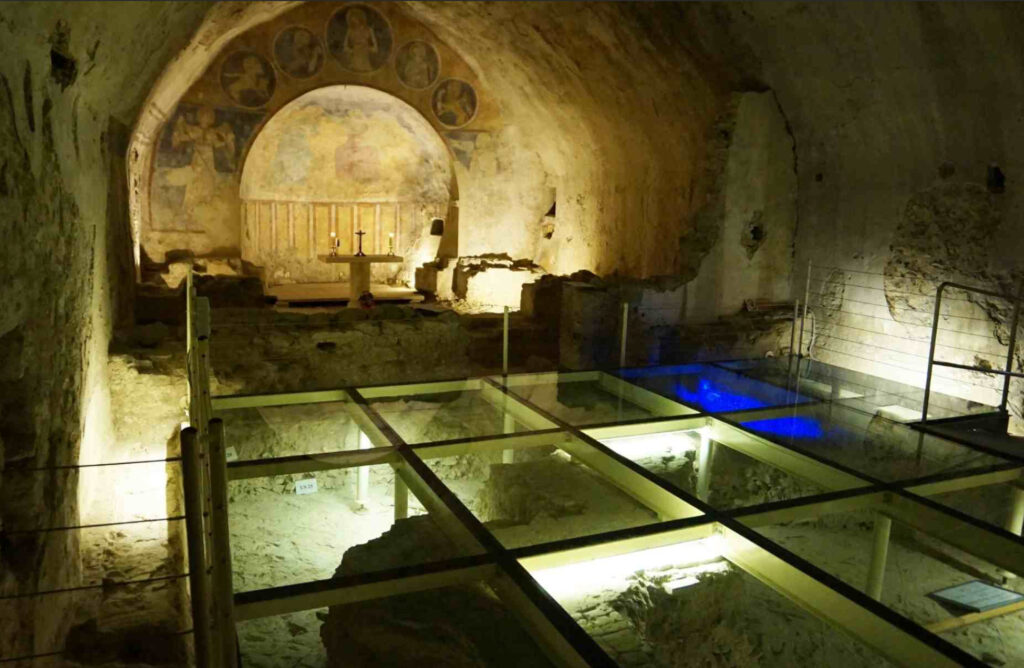
- Narni Underground: Discover Roman ruins and medieval secrets beneath the city.
- Ponte d’Augusto: Visit the remains of the ancient Roman bridge over the Nera River.
Accommodation:
- Hotel dei Priori: A historic building offering quaint rooms with panoramic views of the Umbrian countryside.
Dining:
- Local Specialties: Try Strangozzi alla Narni, a local pasta with truffles, at Osteria dei Priori.
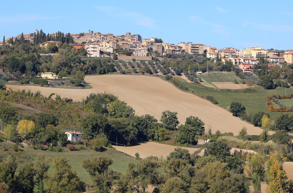
Day 2: Narni to Spoleto via Otricoli and Carsulae
Morning: Visit Otricoli
- Travel: Short drive to Otricoli.
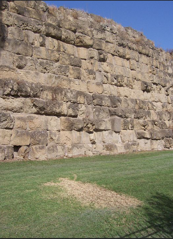
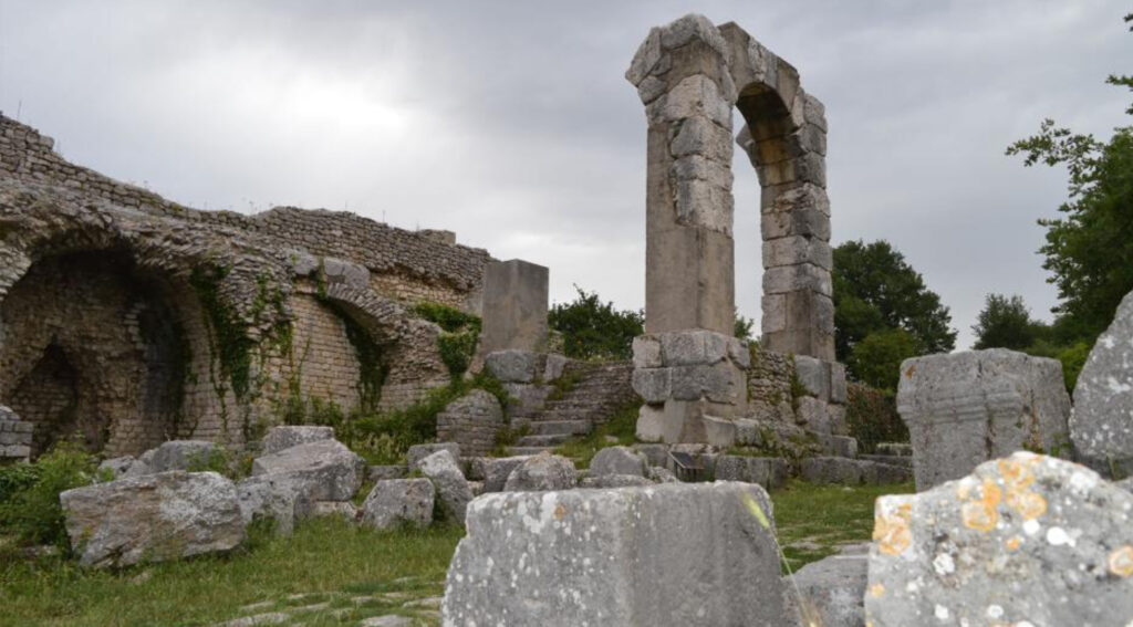
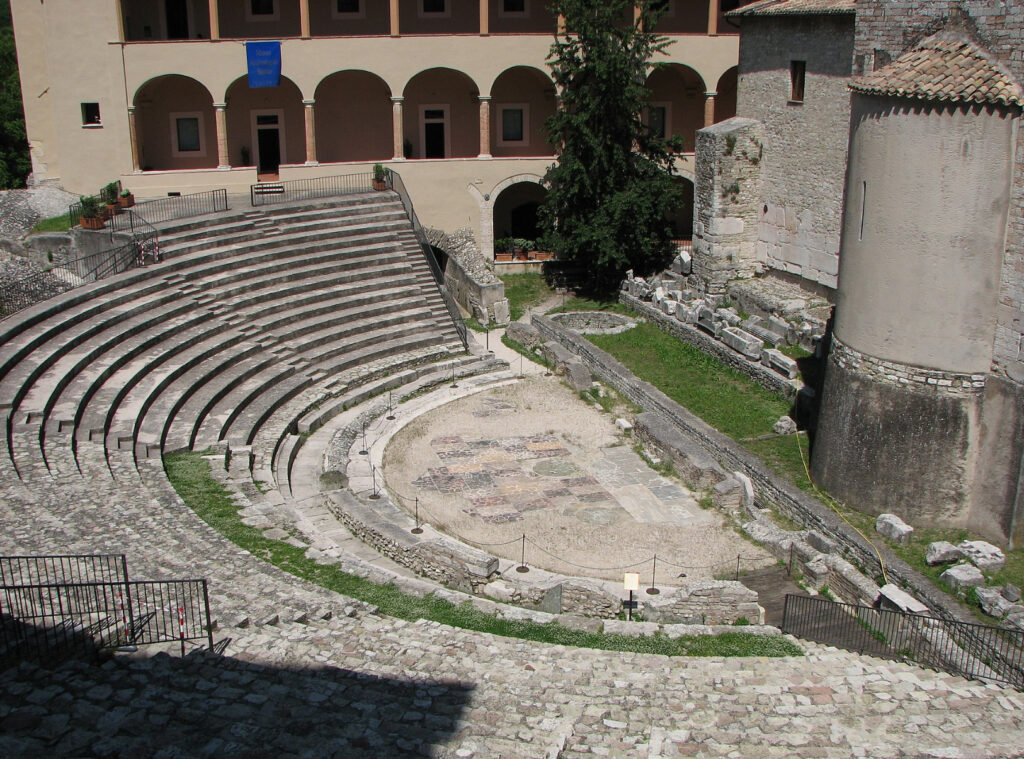
- Archaeological Park of Ocriculum: Explore ruins including baths, amphitheater, and forum along the ancient Via Flaminia.
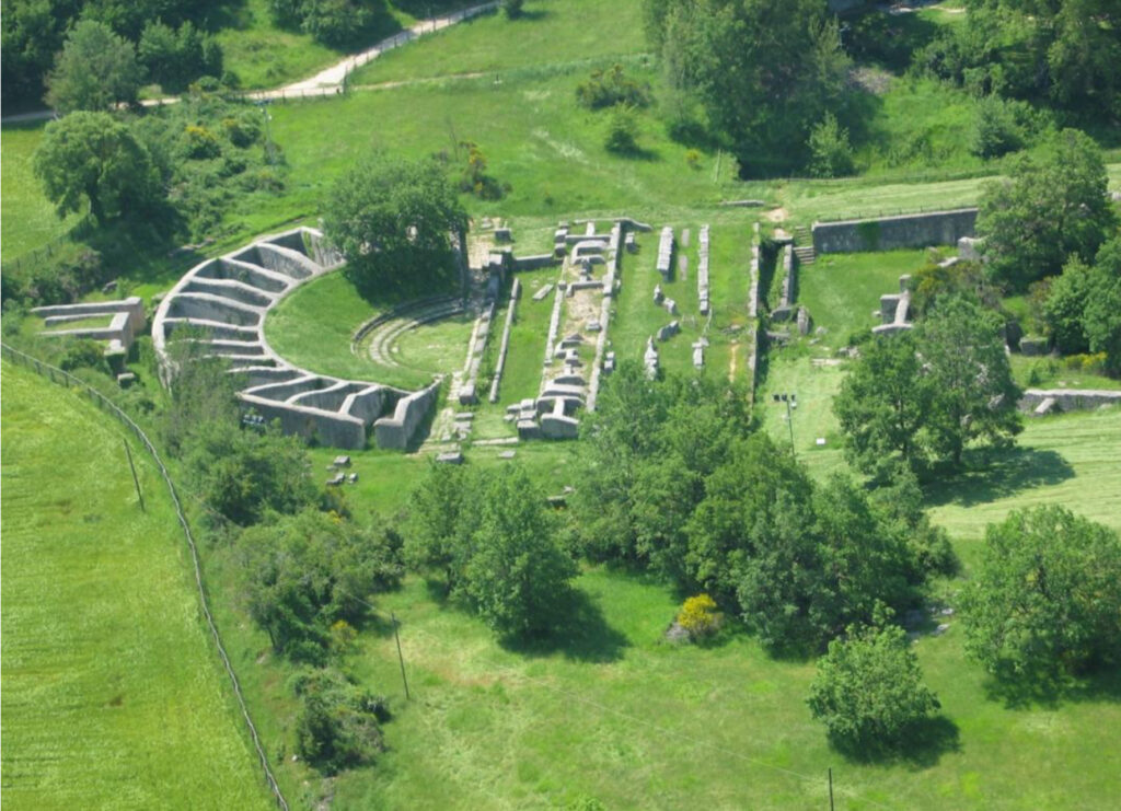
Afternoon: Carsulae Archaeological Site
- Travel: Continue to Carsulae.
- Explore: Visit the well-preserved ruins, including the forum, amphitheater, and stretches of Via Flaminia’s original paving stones.
- Short Hike:
- Trail: Walk along the ancient road within the archaeological park (~2 km).
- Highlights: Experience the original paving stones and Roman milestones.
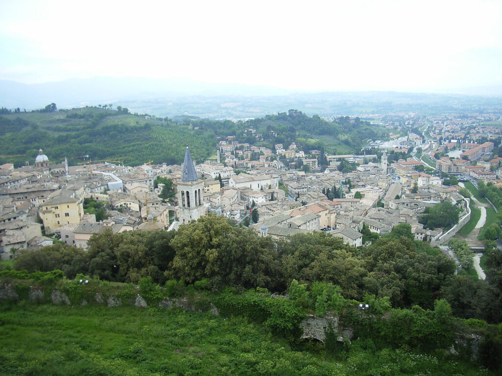
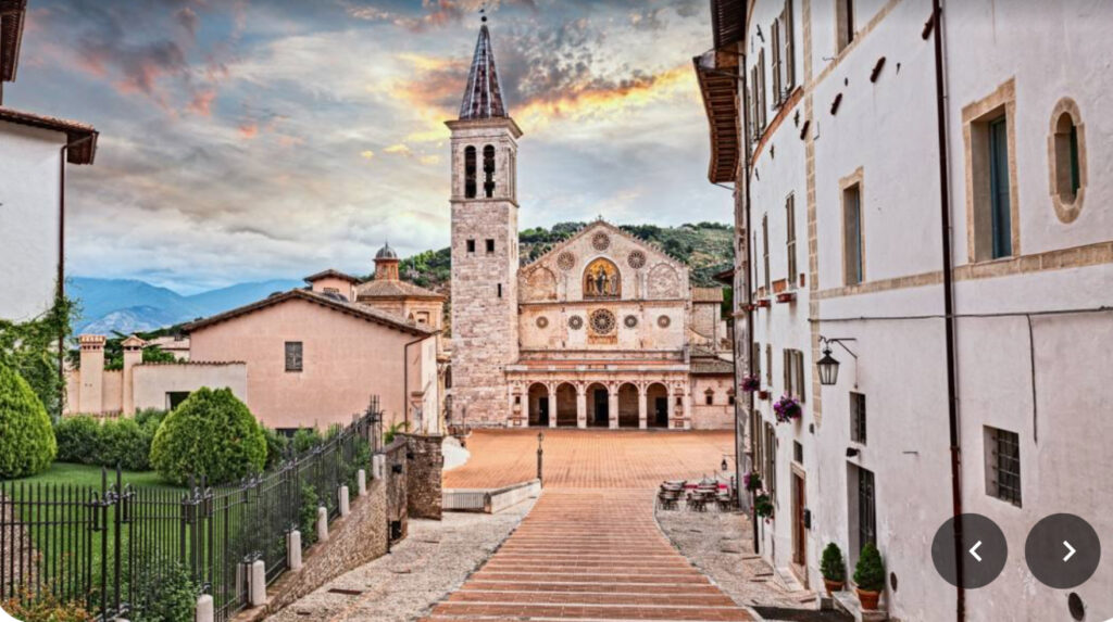
Evening: Arrival in Spoleto
- Travel: Proceed to Spoleto, rich in history and art.
- Explore Spoleto (time permitting):
- Rocca Albornoziana: Visit the imposing fortress.
- Ponte delle Torri: Admire the impressive aqueduct-bridge.
Accommodation:
- Hotel San Luca: A charming hotel in a restored 19th-century building near the historic center.
Dining:
- Local Specialties: Enjoy Rocciata, a traditional Umbrian dessert, at Trattoria del Festival.
Day 3: Spoleto to Trevi via Hiking the Via Flaminia
Morning: Hike from Spoleto to Campello sul Clitunno
- Distance: Approximately 11 km (6.8 miles)
- Duration: About 3-4 hours (easy to moderate trail)
- Route:
- Start at Spoleto: Begin your hike from the outskirts of Spoleto.
- Follow the Ancient Path: The trail follows segments of the Via Flaminia, passing through olive groves and rolling hills.
- Highlights:
- Scenic Views: Enjoy panoramic vistas of the Umbrian countryside.
- Local Flora and Fauna: Observe the rich biodiversity along the trail.
Afternoon: Visit Fonti del Clitunno
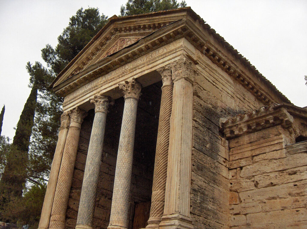
- Fonti del Clitunno: A sacred spring revered since Roman times.
- Temple of Clitunno: Visit this small Roman temple, a UNESCO World Heritage Site.
- Lunch: Picnic by the tranquil waters of the Clitunno Springs (pack a lunch or purchase provisions in Campello sul Clitunno).
Continue Hiking to Trevi
- Distance: Approximately 8 km (5 miles)
- Duration: About 2-3 hours (moderate trail)
- Route:
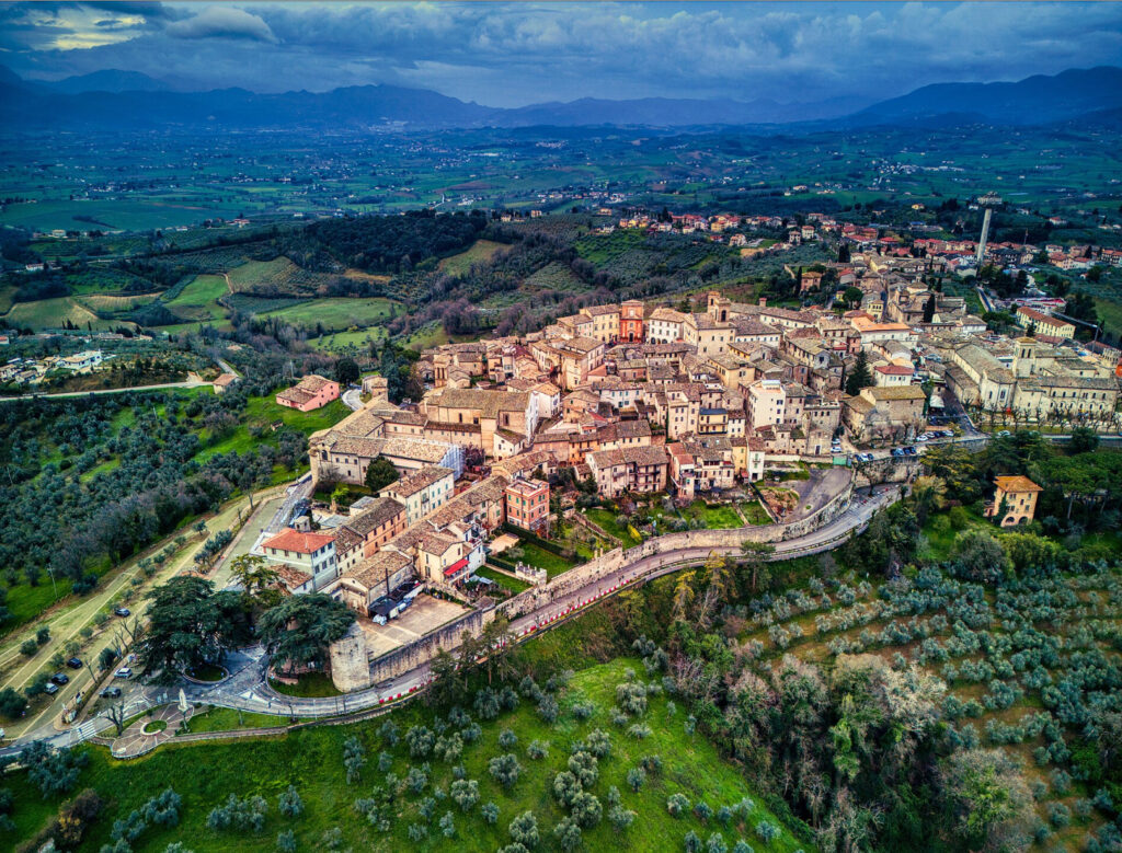
- Ascend to Trevi: The trail becomes steeper as you approach Trevi, known as the “City of Olive Oil.”
- Arrival in Trevi:
- Explore: Wander through medieval streets and enjoy the town’s historic charm.
Accommodation:
- Antica Dimora alla Rocca: A historic residence offering comfortable rooms in the heart of Trevi.
Dining:
- Local Specialties: Try Brustengolo, a traditional cornmeal cake, at Ristorante La Vecchia Posta.
- Olive Oil Tasting: Sample local extra virgin olive oil, renowned for its quality.
Day 4: Trevi to Foligno via Hiking the Via Flaminia
Morning: Hike from Trevi to Foligno
- Distance: Approximately 15 km (9.3 miles)
- Duration: About 4-5 hours (moderate trail)
- Route:
- Descend from Trevi: Begin your hike downhill, rejoining the route of the Via Flaminia.
- Through Olive Groves and Vineyards: The trail winds through picturesque landscapes.
- Highlights:
- Abbey of Sassovivo:
- Detour: Visit this 11th-century Benedictine abbey nestled in the woods (~2 km off the main trail).
- Cloister: Admire the beautiful Romanesque cloister with over 100 small paired columns.
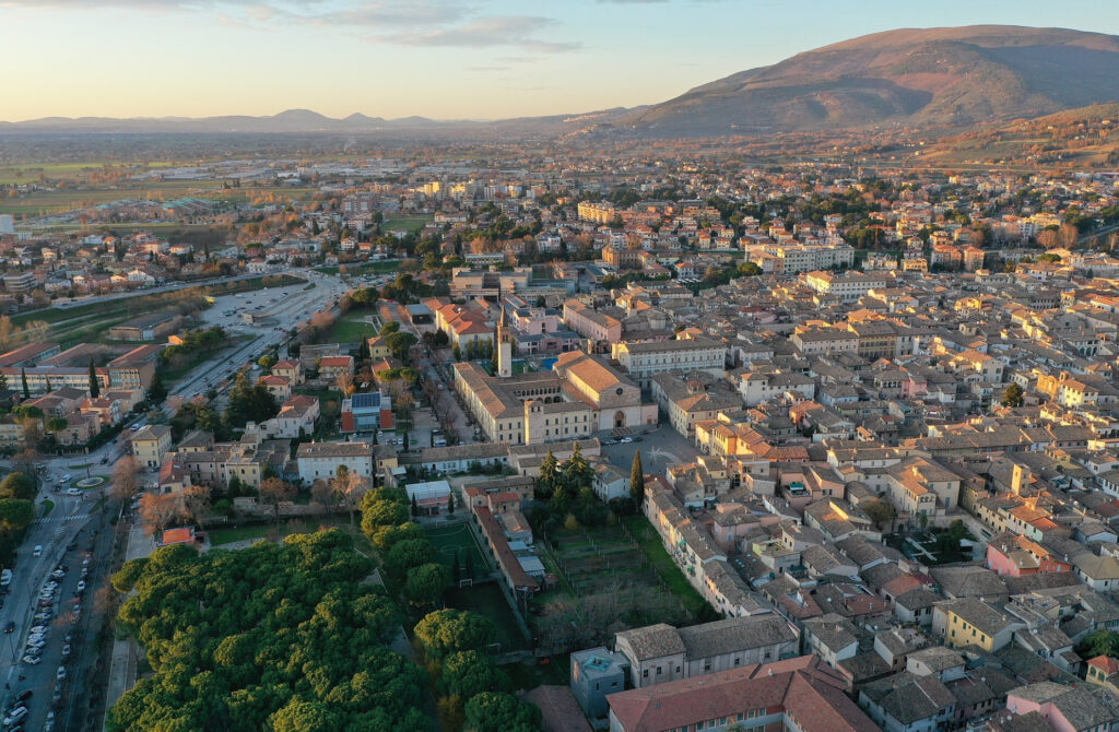
Afternoon: Arrival in Foligno
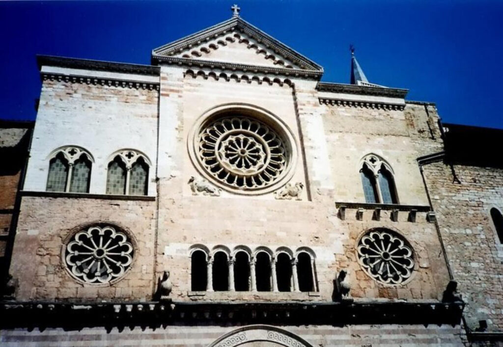
- Explore Foligno:
- Historic Center: Visit the Cathedral of San Feliciano and Palazzo Trinci.
- Art and Culture: Explore galleries and enjoy street performances if available.
Accommodation:
- Villa dei Platani Boutique Hotel & Spa: A stylish hotel offering modern amenities and a spa for relaxation.
Dining:
- Local Specialties: Savor Torta al Testo, a traditional Umbrian flatbread, at Ristorante Il Cavaliere.
- Wine Tasting: Enjoy local wines at Enoteca la Lumaca Ubriaca.
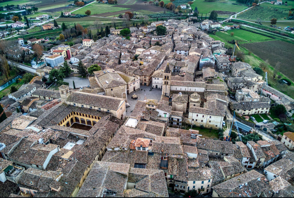
Day 5: Foligno to Gubbio via Bevagna and Hiking Near Gualdo Tadino
Morning: Visit Bevagna
- Travel: Short drive to Bevagna.
- Explore Bevagna:
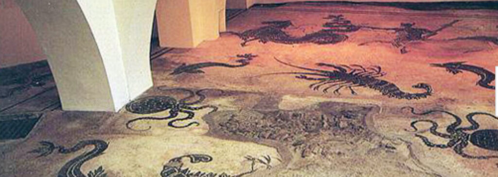
- Piazza Silvestri: Admire Romanesque churches of San Michele and San Silvestro.
- Roman Mosaic: Visit the remains of Roman baths with intricate mosaics.
Afternoon: Hiking Near Gualdo Tadino
- Travel: Proceed to Gualdo Tadino.
- Hike the Sentiero Italia Near Via Flaminia:
- Distance: Approximately 10 km (6.2 miles)
- Duration: About 3-4 hours (moderate trail)
- Route:
- Monte Serrasanta Trail: Offers panoramic views of the Apennines.
- Historical Connection: Though not directly on Via Flaminia, the trail provides context to the region’s geography.
- Highlights:
- Hermitage of Serrasanta: A small sanctuary with stunning vistas.
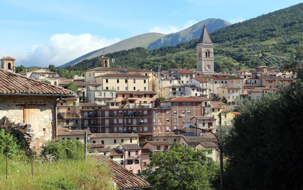
Evening: Arrival in Gubbio
- Explore Gubbio:
- Roman Theatre: One of the best-preserved Roman theatres.
- Piazza Grande: Enjoy views from the heart of the town.
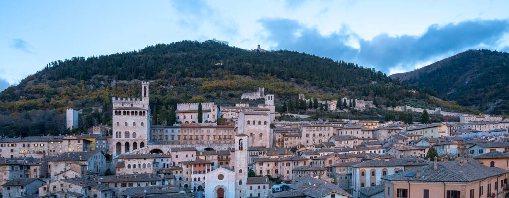

Accommodation:
- Park Hotel ai Cappuccini: A restored 17th-century monastery blending ancient spaces with modern luxury.
Dining:
- Local Specialties: Try Crescia with local cured meats at Taverna del Lupo.
- Truffle Dishes: Gubbio is famous for its truffles; sample dishes at Ristorante dei Consoli.
Day 6: Gubbio to Fano via Furlo Pass
Morning: Furlo Pass Exploration and Hike
- Travel: Drive to the Furlo Pass.
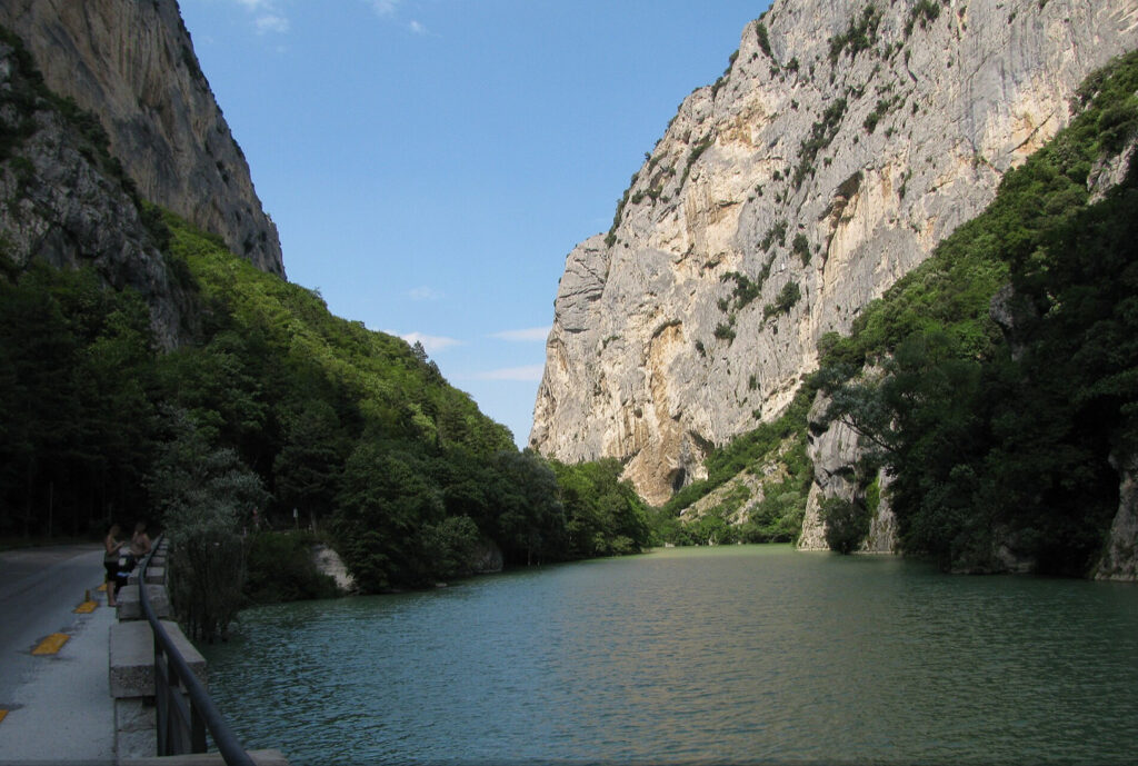
- Hiking the Furlo Gorge:
- Distance: Choose from several trails ranging from 5 to 12 km (3 to 7.5 miles).
- Duration: 2-5 hours depending on the trail (moderate difficulty).
- Route:
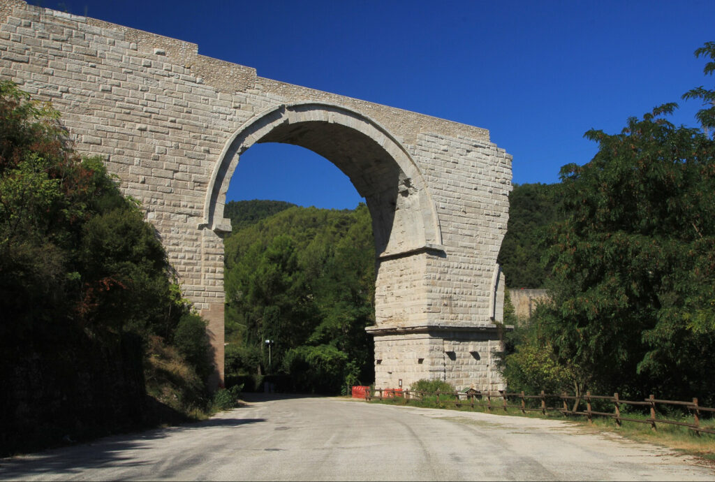
- Via Flaminia Segments: Walk along parts of the ancient road carved into the gorge.
- Galleria Romana: Pass through the Roman tunnel built by Emperor Vespasian.
- Highlights:
- Scenic Beauty: Steep limestone cliffs and the Candigliano River.
- Wildlife: Opportunity to spot golden eagles, peregrine falcons, and other wildlife.
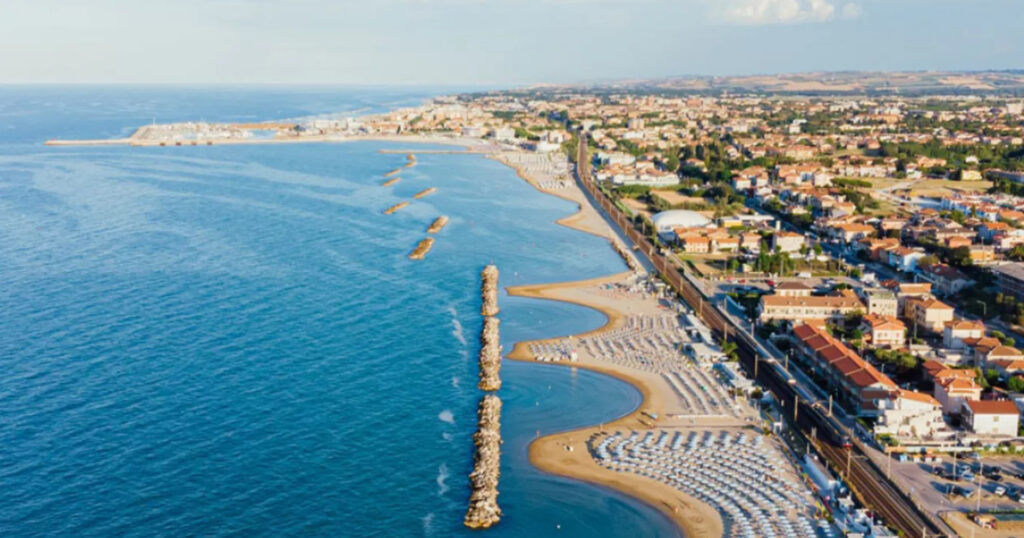
Afternoon: Arrival in Fano
- Explore Fano:
- Arch of Augustus: The main gate of Roman Fano.
- Historic Center: Stroll through the medieval streets.
Accommodation:
- Castello di Monterado: A castle hotel in nearby Monterado, offering frescoed rooms and tranquil gardens.
Dining:
- Local Specialties: Indulge in Brodetto alla Fanese, a traditional fish stew, at La Liscia Da Mr. Ori.
- Seafood Delights: Enjoy fresh Adriatic seafood.
Day 7: Fano to Rimini
Morning: Travel to Rimini
- Travel: Drive along the coast to Rimini (~1 hour).
Explore Rimini:
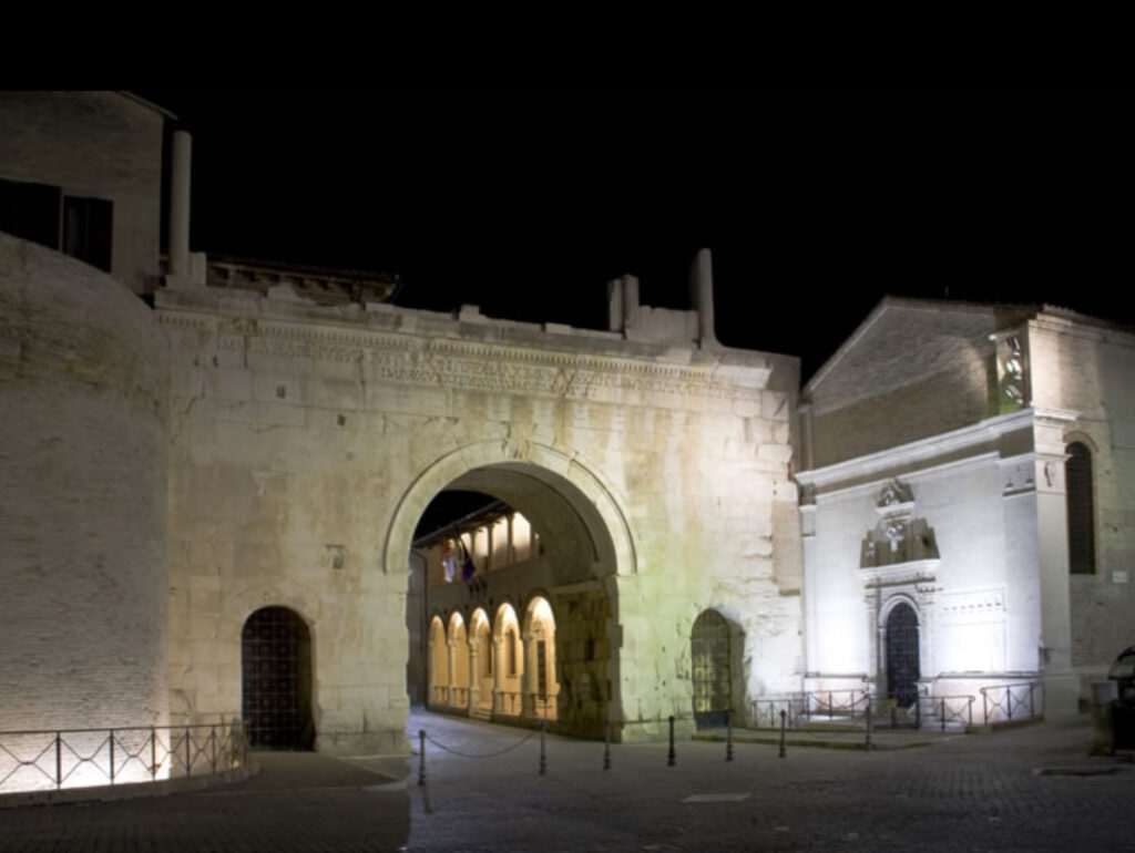
- Historic Sites:
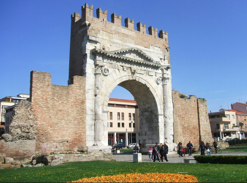
- Arch of Augustus: The oldest surviving Roman arch.
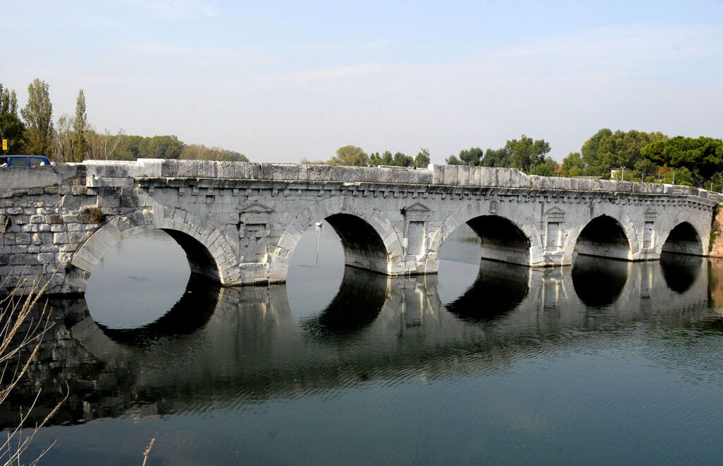
- Tiberius Bridge: A Roman bridge still in use.
- Surgeon’s House: Archaeological site with mosaics.
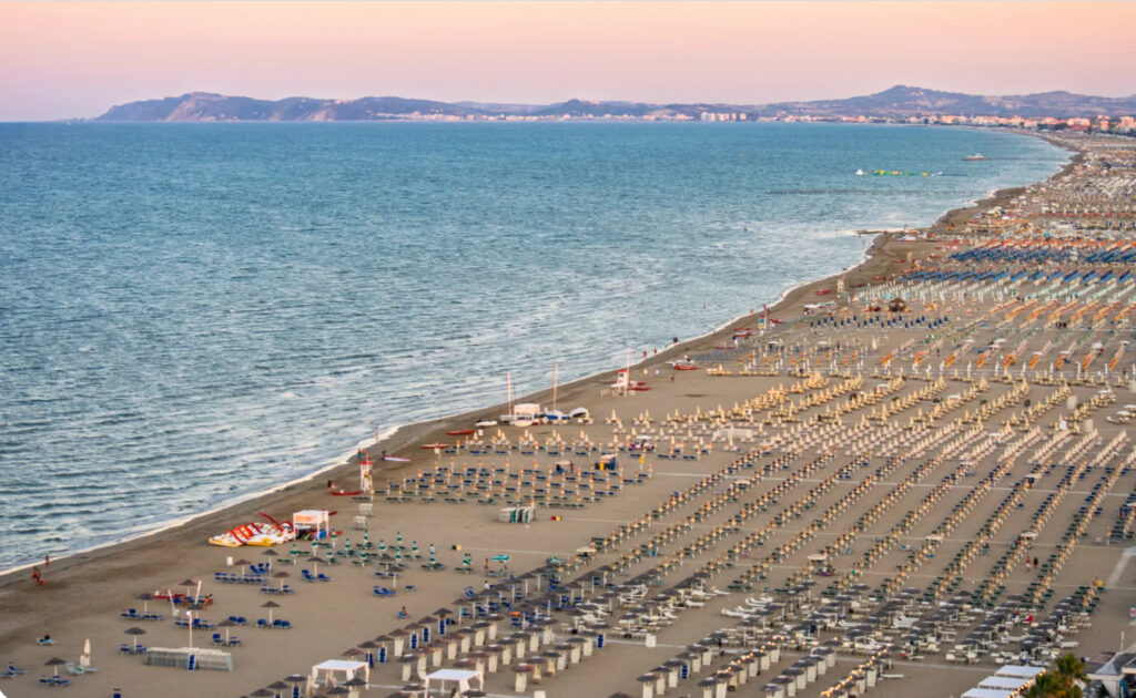
- Beach Time:
- Relax: Enjoy Rimini’s sandy beaches or a stroll along the promenade.
Accommodation:
- Grand Hotel Rimini: An iconic five-star hotel dating back to 1908, featuring elegant rooms and a private beach.
Dining:
- Local Specialties: Taste Piadina Romagnola at Casina del Bosco.
- Gelato Treats: Visit Gelateria Il Castello for authentic Italian gelato.
Additional Highlights and Tips
- Hiking Preparedness:
- Gear: Wear sturdy hiking boots, carry a daypack with water, snacks, a hat, sunscreen, and a map or GPS device.
- Weather: Check forecasts; trails can be muddy after rain.
- Safety: Inform someone of your plans, stay on marked trails, and consider hiring a local guide for unfamiliar routes.
- Cultural Experiences:
- Festivals: Look out for local events like the Infiorata Flower Festival in Spello or Giostra della Quintana in Foligno.
- Local Markets: Visit markets in towns for regional products like cheeses, cured meats, and handicrafts.
- Transportation:
- Luggage Transfers: Arrange for your luggage to be transferred between accommodations while you hike.
- Public Transport: Use trains or buses when needed to shorten travel times or skip less interesting segments.
- Historical Context:
- Via Flaminia Markers: Look for Roman milestones and informational plaques along the trails.
- Museums: Visit local museums to deepen your understanding of the area’s Roman history.
- Culinary Delights:
- Wine Regions: You’re traversing some of Italy’s prime wine areas—don’t miss tastings in Montefalco and Bevagna.
- Olive Oil: Taste and purchase high-quality Umbrian olive oil, especially in Trevi.
In Summary, this revised itinerary adds substantial hiking along the Via Flaminia on Day Three and Day Four, allowing you to immerse yourself in the historical and natural landscapes of central Italy. You’ll walk along paths once tread by ancient Romans, explore charming medieval towns, enjoy regional culinary specialties, and stay in unique accommodations that reflect the area’s rich heritage. This journey not only traces the physical route of the Via Flaminia but also connects you deeply with the culture and history of the regions you pass through.