ChatGPT:
Wroxeter, UK: Origin, History, and Development
Introduction
Wroxeter is a small village located in Shropshire, England, renowned for its rich Roman heritage. It stands on the site of Viroconium Cornoviorum, which was once the fourth-largest city in Roman Britain. Today, Wroxeter offers a fascinating glimpse into ancient history through its archaeological remains, making it a significant site for understanding Roman urban life in Britain.
Origin
Roman Foundation
• Strategic Location: Around AD 58, the Romans established a legionary fortress at Wroxeter. Its proximity to the River Severn and the terminus of Watling Street—a major Roman road—made it a strategic military and logistical hub.
• Military Beginnings: The fortress initially housed the Legio XIV Gemina and later the Legio XX Valeria Victrix. It served as a base for campaigns against the Welsh tribes and to control the native Cornovii people.
History
Roman Period
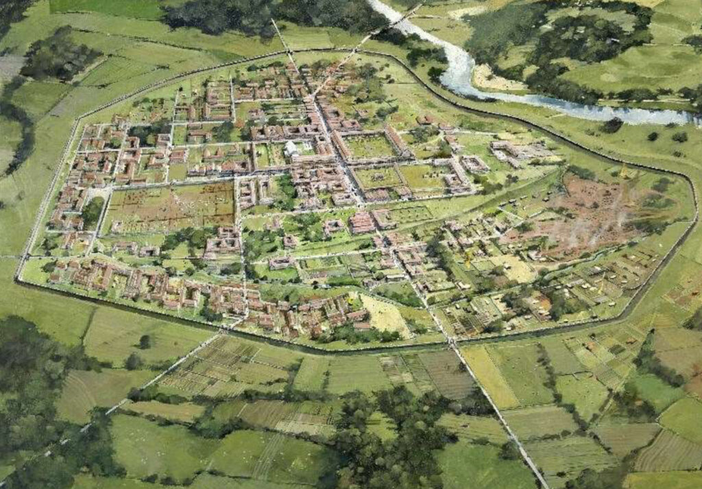
• Transition to a Civilian City: By AD 88, the military garrison relocated, and the site evolved into a civilian settlement named Viroconium Cornoviorum. It became the civitas capital of the Cornovii tribe, functioning as an administrative and commercial center.
• Urban Development: The city expanded over the next two centuries, featuring:
• Public Buildings: A grand forum, basilica, baths, and temples.
• Infrastructure: A grid street pattern, drainage systems, and defensive walls added in the late 2nd century.
• Economy: Local crafts, trade, and agriculture flourished, with evidence of metalworking and pottery.
• Population: At its zenith, Viroconium covered approximately 173 acres and housed an estimated 5,000 to 15,000 inhabitants.
Post-Roman Period
• Continued Occupation: Despite the Roman withdrawal around AD 410, the city wasn’t immediately abandoned. Archaeological evidence suggests continued occupation into the 5th and 6th centuries.
• Legendary Connections: Some theories, though not universally accepted, link Wroxeter to the Arthurian legends, proposing it as a potential site for Camelot due to its prominence during the sub-Roman period.
Medieval Period
• Decline and Transformation: Over time, the once-thriving city diminished. Materials from Roman buildings were repurposed for new constructions.
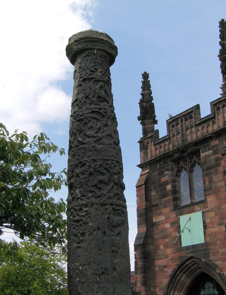
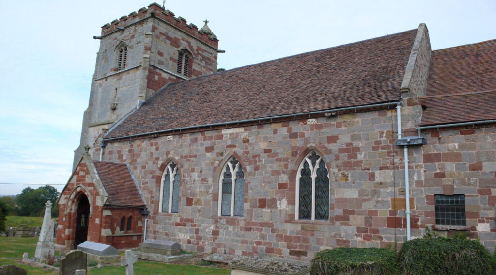
• St. Andrew’s Church: Established in the village, it incorporated Roman stonework, symbolizing the transition from ancient to medieval eras.
• Agricultural Shift: The area became predominantly agricultural, with much of the former city reverting to farmland.
Modern Development
• Archaeological Discoveries:
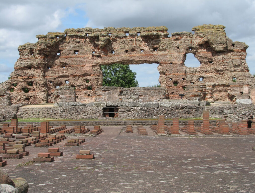
• 19th Century Excavations: Systematic excavations began, uncovering significant structures like the “Old Work”, a substantial fragment of the municipal baths.
• 20th and 21st Century Research: Ongoing excavations have provided deeper insights into the city’s layout, economy, and daily life.
• Tourism and Education:
• English Heritage Site: Wroxeter Roman City is now managed by English Heritage, offering visitors access to the ruins and a museum displaying artifacts.
• Reconstructed Townhouse: In 2010, a replica of a Roman townhouse was built using traditional methods, enhancing educational opportunities.
• Cultural Impact: Wroxeter has been featured in documentaries and educational programs, highlighting its significance in British history.
Conclusion
Wroxeter’s journey from a strategic Roman fortress to a bustling civilian city, and eventually to a quiet village, mirrors the broader narrative of Roman influence in Britain. Its well-preserved ruins provide invaluable insights into ancient urban planning, architecture, and society. Today, Wroxeter stands as a bridge between past and present, inviting exploration and appreciation of Britain’s rich historical tapestry.
Reasons Why Wroxeter Was the End of Watling Street
Introduction
Watling Street was one of the principal Roman roads in Britain, stretching from the southeastern coast to the northwest. It began at Dover (Portus Dubris), passed through Canterbury (Durovernum Cantiacorum) and London (Londinium), and continued northwest through St. Albans (Verulamium) and other settlements before terminating at Wroxeter (Viroconium Cornoviorum). The decision to extend Watling Street to Wroxeter was driven by strategic, military, administrative, and logistical reasons that were crucial to the Roman occupation and control of Britain.
Reasons for Wroxeter Being the End of Watling Street
1. Strategic Military Location
• Frontier Position: Wroxeter was situated near the western frontier of Roman Britain, adjacent to the lands of the Ordovices and Silures tribes in present-day Wales. Extending Watling Street to this point allowed the Romans to maintain a strong military presence close to these unconquered or recently subdued tribes.
• Legionary Fortress: Around AD 58, the Romans established a legionary fortress at Wroxeter for the Legio XIV Gemina and later the Legio XX Valeria Victrix. A direct road facilitated rapid movement of troops and resources to and from this critical military base.
• Campaign Launch Point: Wroxeter served as a staging ground for military campaigns into Wales. The road enabled efficient deployment and supply of forces during operations aimed at consolidating Roman control over the region.
2. Administrative and Economic Significance
• Civitas Capital: After the transition from a military fortress to a civilian settlement by AD 88, Wroxeter became the civitas capital of the Cornovii tribe. As an administrative center, it required robust connections to other parts of Roman Britain for governance and communication.
• Trade and Commerce: Extending Watling Street to Wroxeter integrated the city into the wider Roman trade network. It allowed for the movement of goods such as pottery, metalwork, and agricultural products, boosting the local economy and facilitating taxation.
3. Logistical Practicality
• Geographical Considerations: West of Wroxeter lies the rugged terrain of Wales, which posed significant challenges for road construction and military logistics. Ending Watling Street at Wroxeter, where the terrain was more navigable, was a practical decision.
• Transportation Efficiency: The road provided a direct and efficient route connecting the southeast ports to the northwest, optimizing travel times for officials, merchants, and the military.
4. Integration into the Roman Road Network
• Connectivity: Watling Street was part of a broader network of Roman roads designed to connect key locations across Britain. By terminating at Wroxeter, the Romans ensured that this significant city was fully integrated into their transportation and communication systems.
• Extension Potential: While Watling Street officially ended at Wroxeter, other roads and routes extended into Wales and the northern territories, albeit less developed. Wroxeter acted as a hub from which these lesser roads branched out.
5. Symbolic Representation of Roman Authority
• Demonstration of Control: Establishing a major road terminating at Wroxeter symbolized the extent of Roman reach and their intent to dominate the entire island.
• Urban Development Catalyst: The presence of Watling Street likely contributed to the growth and prosperity of Wroxeter, reinforcing Roman culture and influence in the region.
Conclusion
Wroxeter’s role as the end point of Watling Street was a strategic choice by the Romans, driven by military necessity, administrative efficiency, and economic integration. The road enabled effective control over the western frontier, facilitated trade and governance, and symbolized Roman authority. By terminating Watling Street at Wroxeter, the Romans maximized their operational capabilities while respecting the logistical limitations posed by the challenging terrain to the west. This decision significantly impacted the development of Wroxeter, cementing its place as a major urban center in Roman Britain.
Additional Context
• Watling Street’s Importance: As one of the primary arteries of Roman Britain, Watling Street was crucial for moving legions, communicating orders, and transporting goods across the province.
• Post-Roman Legacy: The route of Watling Street remained significant even after the Roman withdrawal, influencing the development of medieval roads and modern highways.
• Archaeological Evidence: Excavations along Watling Street and at Wroxeter have uncovered artifacts and structural remains that highlight the road’s role in facilitating Roman occupation and the city’s prominence.
Remaining Historical Monuments in Wroxeter, UK
Wroxeter is rich in historical monuments that reflect its past as one of the most significant cities in Roman Britain. Here is a list of the key remaining historical monuments you can explore:
1. Wroxeter Roman City (Viroconium Cornoviorum)
• Description: Managed by English Heritage, the site features extensive ruins of the Roman city, including streets, foundations of houses, and public buildings.
• Highlights:
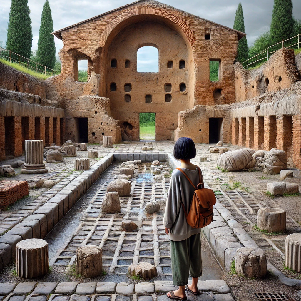
• The Old Work: A substantial fragment of the basilica wall, standing over 7 meters high, it is one of the largest free-standing pieces of Roman wall in Britain.
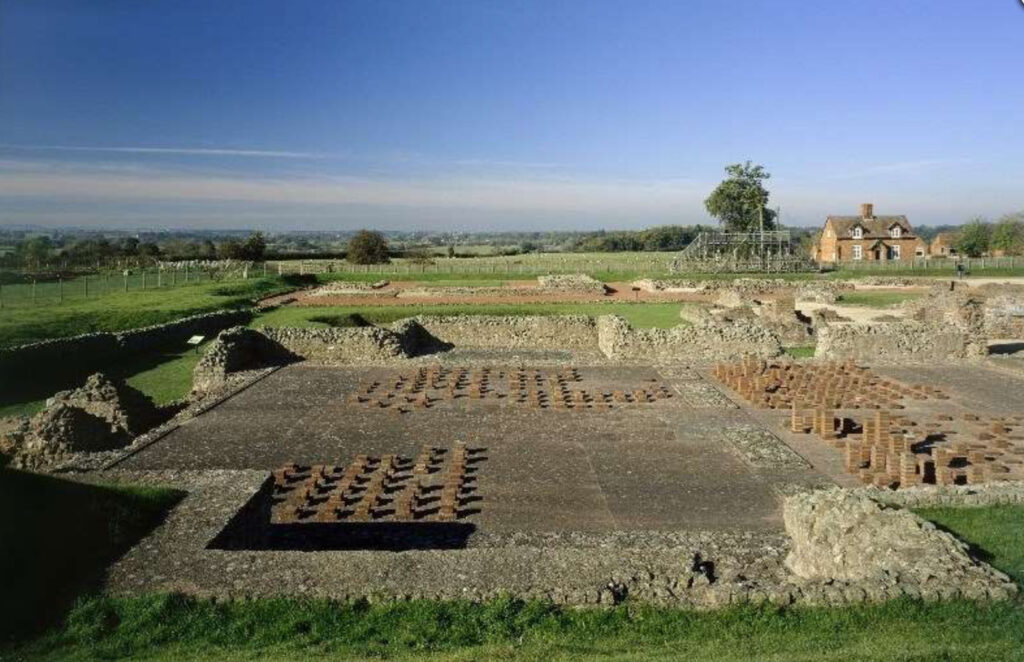
• Bath Complex: Remains of the public baths, showcasing the layout of Roman bathing facilities, including the hypocaust (underfloor heating system).
• Market Hall and Forum: Foundations indicating the commercial heart of the ancient city.
2. Reconstructed Roman Town House
• Description: Built in 2010 using traditional Roman construction techniques, this full-scale replica provides insight into Roman domestic architecture and daily life.
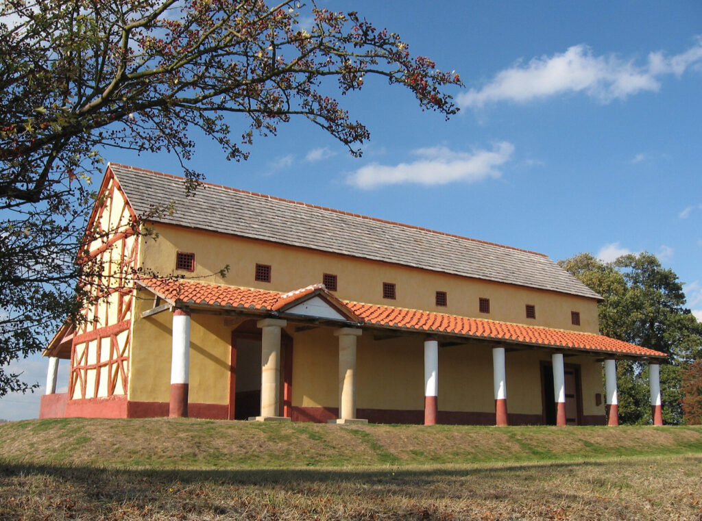
• Features:
• Authentic interior decorations and mosaics.
• Furnishings based on archaeological findings.
3. St. Andrew’s Church
• Description: A medieval church dating back to the 12th century, incorporating Roman stones and materials into its structure.
• Notable Aspects:
• Norman Architecture: Features typical of Norman ecclesiastical design.
• Historic Churchyard: Contains graves and monuments spanning several centuries.
4. Roman City Walls and Earthworks
• Description: Remnants of the defensive walls that once surrounded Viroconium.
• Observations:
• Visible earthworks outlining the perimeter of the ancient city.
• Sections of ditches and ramparts.
5. Wroxeter Vineyard
• Description: While not ancient, the vineyard is situated on land historically associated with Roman viticulture.
• Relevance:
• Reflects the continuation of agricultural practices dating back to Roman times.
• Offers tours that include discussions of historical cultivation methods.
6. Roman Roads and Infrastructure
• Description: Traces of Roman roads such as Watling Street can still be identified in the landscape.
• Significance:
• Demonstrates the city’s connectivity within Roman Britain.
• Provides context for the city’s strategic importance.
7. Archaeological Finds Display
• Location: On-site museum at the Wroxeter Roman City.
• Exhibits:
• Artefacts such as pottery, tools, jewelry, and coins discovered during excavations.
• Interactive displays explaining the history and significance of the site.
8. The Old Rectory
• Description: A historic building dating back to the 18th century, reflecting post-medieval architecture.
• Current Use: Now serves as private residences but contributes to the historical ambiance of the village.
9. Site of the Roman Amphitheatre
• Description: Although not fully excavated, the location of the amphitheatre is known and marked.
• Importance:
• Indicative of the city’s size and cultural life.
• Potential site for future archaeological exploration.
10. Medieval Village Earthworks
• Description: Remains of the medieval settlement that developed after the decline of the Roman city.
• Features:
• Foundations of buildings.
• Relics of medieval agriculture, such as ridge and furrow patterns.
Visiting Information
• Access: Most of the monuments, especially those managed by English Heritage, are accessible to the public with facilities like guided tours and educational materials.
• Conservation: Visitors are encouraged to respect the preservation efforts by adhering to site guidelines.
Conclusion
These monuments offer a tangible connection to Wroxeter’s rich historical narrative, from its prominence in Roman Britain to its evolution through the medieval period. Exploring these sites provides valuable insights into ancient urban planning, architecture, and the continuity of community life through the centuries.